 |
|
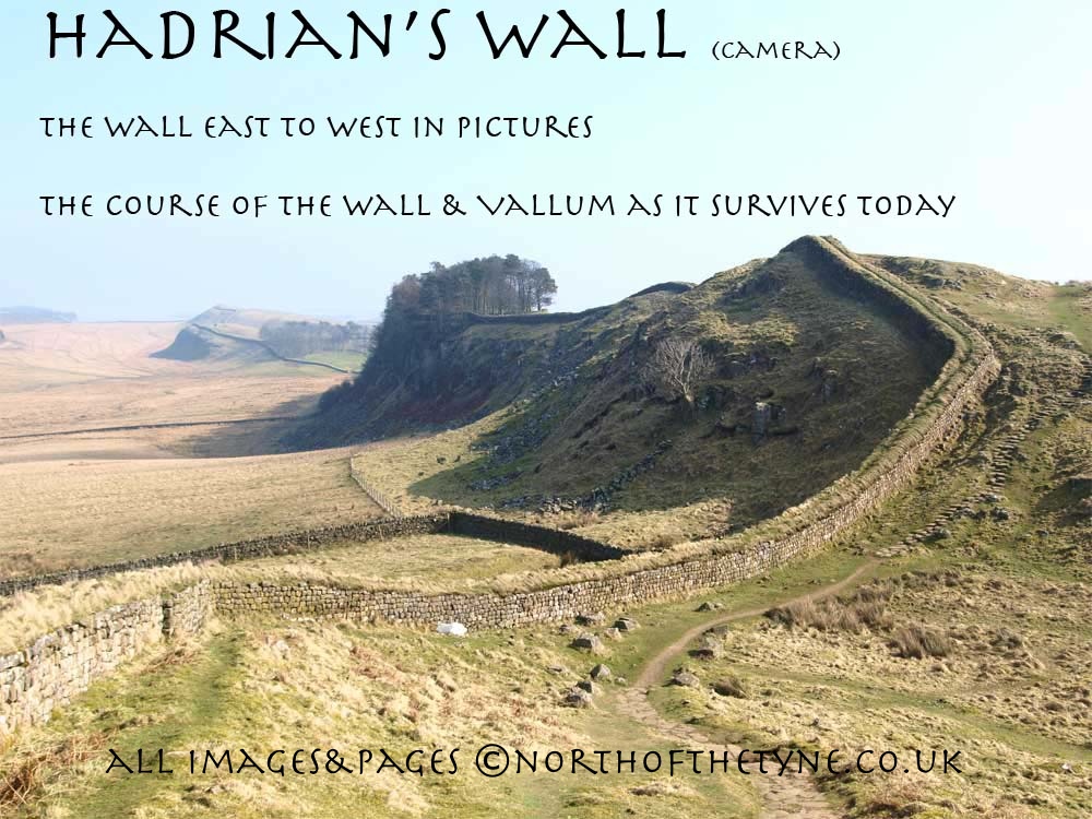
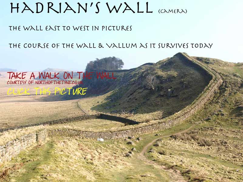
Page IX
Housesteads to Windshields Crags
Milecastles 37 to 40
|
|
 |
|
|
 |
|
 |
|
|
|
|
 |
|
|
|
VERCOVICIUM to Milecastle 40
Housesteads to Windshields Crags
The Wall leaves for the west past Milecastle 37 and runs along the ridge of Highshields Crags and past Sycamore Gap to Peel Crags this page covering 3 Roman miles. to the first of Windshields Crags
Hadrian's Wall is a World Heritage Site
Roman Mile = 1620 yards = 0.92Mile = 1.48km

Start point for this page
|
|
 |
|
|
Location
|
Milecastle
|
|
Segedunum to Pons Aelis
|
|
|
Pons Aelis to Condercum
|
|
|
Condercum to Heddon
|
|
|
Heddon to Harlow Hill
|
|
|
Harlow Hill to Portgate
|
|
|
Portgate to Chesters
|
|
|
Chesters to Brocolitia
|
|
|
Brocolitia to Vercovicivm
|
|
|
Vercovicivm to MC40
|
|
|
MC40 to Aesica
|
|
|
Aesica to Carvoran
|
|
|
Carvoran to Birdoswald
|
|
|
Birdoswald to Hare Hill
|
|
|
Hare Hill to Newton
|
|
|
Newton to Stanwix
|
|
|
Stanwix to Dykesfield
|
|
|
Dykesfield to Maia
|
|
|
|
|
|
|
|
|
|
|
|
|
|
|
|
|
|
|
|
Henry Mclaughlan's drawing of Borcovicus
|
|
|
|
 |
|
|
|
|
 |
|
 |
|
 |
|
|
 |
|
|
 |
|
|
VERCOVICIUM FORT
at Housesteads
The jewel in the crown when viewing the Wall, this fort sits high on the Great Whin Sill and the layout so much of which is still intact, has offered insight into aspects of the lives lived by the defenders of this North West frontier on the Roman Empire to Archeologists and Historians over the last 300 years .
The Fort's Roman name without any authority was often given as BORCOVICUS. The Notitia Dignitatum (fifth century) suggests BORCOVICIUM while the Ravenna List (seventh century) gives VELURTION. An inscription from the site starts with the letters VER and hence VERCOVICIUM (the hilly place) has been suggested........... the name of the 18th century Farmhouse HOUSESTEADS is the modern name. *1
The Housesteads site has been included in the study of the wall since Bainbridge sent an account of it to Camden in 1601. No single piece of evidence has so far been discovered which provides an approximate date for the start of construction...............In the course of Simson and Richmond's excavation in 1945, the foundations of Turret 36b in their appropriate position according to the spacing of the First Plan were exposed under the stucture of the Fort itself. Enough existed and is preserved to demonstrate clearly that it had been partially built in accordance with the First Plan........................and that it had been demolished to make way for the great infantry fort demanded by the Second Plan. *2
In the original Hadrianic fort there were ten barracks intended for a military cohort of about 800 men it is not known for certainty. but it is likely to have been cohors I Tungrorum militaria and the Tungarians were certainly in garrison by the end of the second century. The Tungarians were raised in Belgium and were known to have served at other forts (Vindolanda and Carrawburgh)*3
The Fort was destroyed three times, in 197A.D., 296 and 367.
The first rebuilding was by Severus soon after 200 A.D. and in the fourth century by Anglo Saxons
By 400 A.D. the garrison had declined to two or three hundred. The headquarters building was then used as an armoury and a smith was turning out arrowheads when sudden destruction came to Housesteads. * 4
|
|
|
|
 |
|
|
 |
|
|
 |
|
 |
|
|
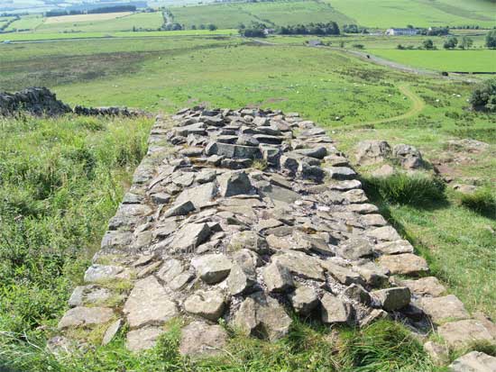
The site of Turret 36b built over by Housesteads north wall
|
|
|
|
|
|
|
|
 |
 |
|
 |
|
 |
|
 |
|
|
Leaving the great fort at Housesteads the Wall heads west and into a small wood where the public have permission to walk on the Wall itself. Emerging on to moorland the Wall follows the edge of this part of the Great Whin Sill called not surprisingly Housesteads Crags.
Within a short distance the site of Milecastle 37 is encountered with its elaborate Gateway overlooking a cliff !!
|
|
|
|
|
|
|
|
|
|
 |
 |
 |
|
The site of Milecastle 37
West of Housesteads Fort
|
|
|
|
|
|
|
|
|
|
|
 |
 |
|
 |
|
|
The Whin Sill is one of the North's most distinctive geographical features.This rocky outcrop is part of a huge sheet of rock which starts at the Farne Islands and runs along the Roman Wall and then under the Pennines. Molten rock was pushed up from the earth's surface, cooled, crystallised and formed the Whin Sill as we see it today.
One of the best places to see the Whin Sill is close to Housesteads Fort, one of the best preserved Roman sites in Britain. Housesteads lies on the great volcanic escarpment of Whin Sill. It is one of the 12 forts added to the Wall in about AD124, and was designed to contain a garrison of 800
More info on the Great Whin Sill
|
|
|
|
 |
|
|
Map taken from Horsley's Britannica Romana |
|
 |
|
|
The Wall now follows the undulations of the Whin Sill moving on to Cuddy's Crags
at the western end of which there is a superb abutment
|
|
|
|
|
|
|
 |
 |
 |
|
 |
|
|
|
|
|
|
 |
|
Below Cuddy's Crags and before the climb up onto Hotbanks Crags, the long distance pathway, the Pennine way crosses the line of the Wall.
The "Pennine Way" stretches from Derbyshire to Kirk Yetholm in the borders of Scotland
|
|
|
|
|
|
|
|
 |
 |
|
 |
|
 |
|
 |
The Wall along from Housesteads to Hotbanks was rebuilt by John Clayton in the 1800's where the Wall was not reconstituted it is now in the form of "drystone"
|
|
|
|
|
|
|
|
 |
 |
|
The "Stanegate" fort of VINDOLANDA can be seen down to the south along this stretch. highlighted in this photo
|
|
|
|
|
|
 |
 |
|
 |
|
 |
|
 |
|
|
 |
|
|
|
The site of Milecastle 38
Hotbanks
<<<<<<<<<<
|
|
 |
|
|
|
|
|
 |
|
 |
|
From the western end of Crags at Hotbanks the wall dives down past the farm of the same name and the site of MC 38 and takes a right angle turn to the west to head for Highshield Crags. the Ditch not seen since sewingshields is prominent down from the farm to the corner.
|
|
|
|
|
|
|
 |
 |
 |
|
 |
|
|
|
|
 |
|
 |
|
|
|
 |
|
|
 |
|
 |
******
From the corner at the foot of Hotbanks the wall climbs through a Wood up onto the crest of Highshield crags and stood high above Crag Lough.
|
|
|
|
|
|
|
|
|
|
|
 |
 |
|
At the Western end of Highshield Crags and before climbing again up onto Steel Rigg the wall drops into the much photographed "Sycamore Gap"
|
|
|
|
|
|
 |
|
|
 |
|
 |
|
|
 |
|
|
|
 |
|
 |
|
 |
|
At the top of the slope as the wall continues there are ruins of officers quarters these being for milecastle39 a few hundred yards down the next slope
|
 |
|
|
|
|
|
|
|
|
|
 |
|
The site of Milecastle 39
Castle Nick
<<<<<<<<<<
|
|
|
|
 |
 |
|
|
 |
|
 |
|
|
 |
 |
|
 |
|
 |
|
|
|
 |
|
 |
*********
Views of the Wall from the north side near Peel Crags
|
|
|
|
|
 |
|
|
 |
|
 |
|
|
 |
|
 |
|
 |
|
 |
|
The Extra Turret
The turret at the foot of Peel Crags is an extra turret thought to have been put there to protect this gap in the Whin Sill.
The wall takes a 90 degree turn right for a few hundred yards and then a sharp left and heads directly up the slope to Windshields Crags.
It crosses the modern road that runs up to what is known as the Steel Rigg carpark.
|
|
 |
|
|
|
|
|
 |
 |
|
|
|
|
 |
|
 |
|
|
|
 |
|
 |
|
In the picture below, the Fighting Ditch makes its appearance on the gentle slope up to Milecastle 40
|
|
|
|
|
|
|
|
 |
 |
|
 |
 |
|
|
|
The site of Milecastle 40
NY 746 677
<<<<<<<<<<
|
|
References page 9
*********
*1 Frank Graham - The Roman Wall 1979 Pg 101
*2 David Divine - The North East Frontier of Rome 1969 Pg112
*3 English Heritage - Booklet Guide to Houseteads Roman Fort, reprinted 2008 Pg 42
*4 Frank Graham - The Roman Wall 1979 Pg 99
|
|
|
|
|
|
|
 |
|
|
|
|
|
|
|
|
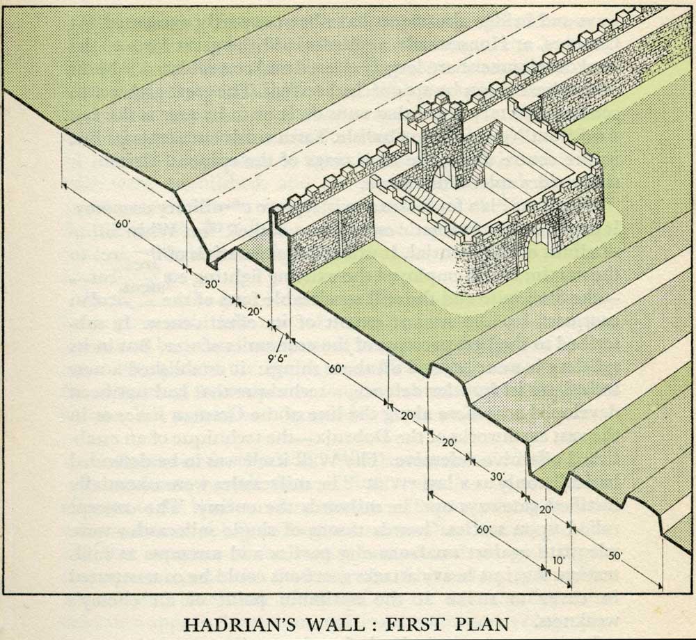 |
Milecastles
This first plan provided for a wall 10ft wide, 15ft 6 inches high and surmounted by a 6ft crenellation. to the north of this was a 20 ft berm, a standard fighting ditch 30ft by 13ft 6 inches, and a glacis composed of the spoil of the ditch, approximately 60ft in width.
At each Roman mile was a milecastle with a north gate opening through the Wall, surmounted by a defensive turret and a south gate. In the original plan there were two barracks and the milecastle maintained a turret on either hand for the patrol garrison.
South of the wall was the Vallum, a complex consisting of a 20 ft ditch with a wide bottom section and mounds composed of spoil to north and south. The wall was built to the design width only on the eastern slope. The Milecastles built before the change of plan had 10ft wings on either side. The curtain wall as finally built was substantially narrower and the join is indicated in the diagram.
This information and the diagram taken from Richard Devine The Northwest Frontier of the Roman Empire Chap2 pg 27
|
|
|
|
|
|
|
 |
 |
|
|
|
|
|
|
|
|
|
|
|
|
|
|
|
|
|
|
|
|
|
|
|
|
|
|
|
|
|
|
|
|
|
|
|
|
|
|
|
|
|
|
|
|
|
|
|
|
|
|
|
|
|
|
|
|
|
|
|
|
|
|
|
|
|
|
|
|


