 |
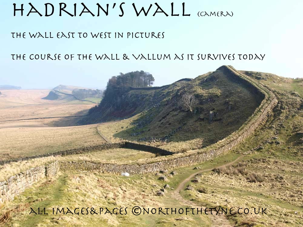
Page VII Chesters to Brocolitia
Milecastles 27 to 31
|
 |
|
||||||||||||||||||||||||||||||||||||||||||||||||||||||||||||||||||||||||||||||||||||||||||||
 |
|||||||||||||||||||||||||||||||||||||||||||||||||||||||||||||||||||||||||||||||||||||||||||||||
 |
|||||||||||||||||||||||||||||||||||||||||||||||||||||||||||||||||||||||||||||||||||||||||||||||
|
CILURNUM Fort to BROCOLITIA Fort The Wall leaves the west gate of CILURNUM runs under the victorian embellishments of John Clayton's original Georgian House. up the slope to Walwick where the Hall was built just to its south and travels in a direct line for 2.5 standard miles to "Limestone Corner" where it holds the high ground and all the western approaches to the NorthTyne valley. This point was for two and a half centuries the northern limit of the Roman Empire. *1 The road covers the wall from the Chesters plantation to the hamlet of Walwick before turning south to run in the Vallum. and it provides the line again after limestone corner on to BROCOLITIA fort and west for a further mile and a half. With the road in the Vallum the line can be traced to Black Carts where it must have climbed spectacularly over the hill. West of Black Carts and Milecastle 29 there are visible remains standing up to six foot in hight and some hundreds of yards in length. The site of Milecastle 27 is shown on the previous page some 400 yards east of the bridge over the North Tyne BROCOLITIA shown as Procolitia in the Notitia and on the 1922 map on this page. Roman Mile = 1620 yards = 0.92Mile = 1.48km
Start point for this page |
 |
|
|||||||||||||||||||||||||||||||||||||||||||||||||||||||||||||||||||||||||||||||||||||||||||||
 |
|||||||||||||||||||||||||||||||||||||||||||||||||||||||||||||||||||||||||||||||||||||||||||||||
 |
|||||||||||||||||||||||||||||||||||||||||||||||||||||||||||||||||||||||||||||||||||||||||||||||
 |
|||||||||||||||||||||||||||||||||||||||||||||||||||||||||||||||||||||||||||||||||||||||||||||||
 |
 |
||||||||||||||||||||||||||||||||||||||||||||||||||||||||||||||||||||||||||||||||||||||||||||||
 |
|||||||||||||||||||||||||||||||||||||||||||||||||||||||||||||||||||||||||||||||||||||||||||||||
|
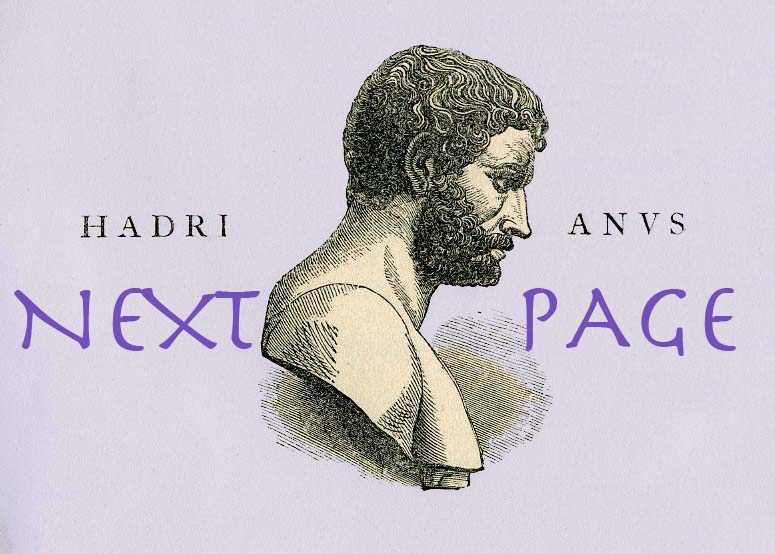
John Clayton 1792 - 1890 There is a superb museum at Chesters in the grounds curated by English Heritage. This museum was founded in memory of John Clayton the former owner of the site. Lovers of the Wall are indebted to Clayton mor than any other man. Not only did he make the first scientific excavations of forts and milecastles, and create a new interest in the archeology of the Wall, he bought up whatever portions of land that came onto the market and thus saved them from probable destruction. In the end he owned five forts on the Wall. *2 The son of Nathanial Clayton (Town Clerk of Newcastle upon Tyne) John become Under-Sheriff in 1816 before succeeding his father as Town Clerk 1822. Nathaniel levelled out and grassed over much of the Roman fort. While doing so he collected various antiquities, but there is no evidence that he took a great deal of interest in the Roman history of his estate. However, from an early age John took a passionate interest not only in the fort of Chesters and its immediate surroundings, Clayton's first published work, in 1843, was his excavation of the commanding officer's bath-house at Chesters. He was involved in excavations most years for the next half-century, both at Chesters and elsewhere along Hadrian's Wall, namely Cawfields (Milecastle 42), Castle Nick (mc 39) and Housesteads Crags (mc 37), Housesteads and Carvoran. His archaeological work continued into his later years, and he was in his early nineties when he uncovered the spectacular sculptures of the temple to Mars Thincsus at Housesteads. Clayton Street in Newcastle upon Tyne is named after him John Clayton here depicted as a Roman Centurion from the painting (1857) by William Bell Scott to be found at Wallington Hall |
|||||||||||||||||||||||||||||||||||||||||||||||||||||||||||||||||||||||||||||||||||||||||||||||
 |
|||||||||||||||||||||||||||||||||||||||||||||||||||||||||||||||||||||||||||||||||||||||||||||||
|
From the West gate of CILURNUM (seen in the first picture) the wall with hardly a deviation drives directly uphill to Limestone Corner passing through the Chesters Estate and thehamlet of Walwick, the line being behind the Hall buiding. Chesters-Cilurnum diagram *6 |
|||||||||||||||||||||||||||||||||||||||||||||||||||||||||||||||||||||||||||||||||||||||||||||||
 |
 |
||||||||||||||||||||||||||||||||||||||||||||||||||||||||||||||||||||||||||||||||||||||||||||||
|
The site of Milecastle 28
At the top of the bank on the left at the hamlet of Walwick |
 |
||||||||||||||||||||||||||||||||||||||||||||||||||||||||||||||||||||||||||||||||||||||||||||||
 |
 |
 |
|||||||||||||||||||||||||||||||||||||||||||||||||||||||||||||||||||||||||||||||||||||||||||||
 |
 |
||||||||||||||||||||||||||||||||||||||||||||||||||||||||||||||||||||||||||||||||||||||||||||||
 |
|||||||||||||||||||||||||||||||||||||||||||||||||||||||||||||||||||||||||||||||||||||||||||||||
 |
 |
||||||||||||||||||||||||||||||||||||||||||||||||||||||||||||||||||||||||||||||||||||||||||||||
 |
 |
||||||||||||||||||||||||||||||||||||||||||||||||||||||||||||||||||||||||||||||||||||||||||||||
|
Behind and beyond Walwick Hall the Wall line runs along the side of and through meadowland with the ditch clearly seen to the north. The "Military Road" A 6318 is occupying the Vallum with evidence of the Military Way between.
|
|||||||||||||||||||||||||||||||||||||||||||||||||||||||||||||||||||||||||||||||||||||||||||||||
 |
 |
||||||||||||||||||||||||||||||||||||||||||||||||||||||||||||||||||||||||||||||||||||||||||||||
 |
|||||||||||||||||||||||||||||||||||||||||||||||||||||||||||||||||||||||||||||||||||||||||||||||
 |
 |
||||||||||||||||||||||||||||||||||||||||||||||||||||||||||||||||||||||||||||||||||||||||||||||
 |
|||||||||||||||||||||||||||||||||||||||||||||||||||||||||||||||||||||||||||||||||||||||||||||||
 |
 |
||||||||||||||||||||||||||||||||||||||||||||||||||||||||||||||||||||||||||||||||||||||||||||||
|
At Black Carts over a minor road the Wall rises sharply to crest the hilltop occupied by a small cottage. Following the rough track beyond it passes through a small field and bracken into a wood. Dropping down the other side to come to the site of Milecastle 29 |
|
||||||||||||||||||||||||||||||||||||||||||||||||||||||||||||||||||||||||||||||||||||||||||||||
|
The site of Milecastle 29 West of Black Carts |
|||||||||||||||||||||||||||||||||||||||||||||||||||||||||||||||||||||||||||||||||||||||||||||||
 |
 |
||||||||||||||||||||||||||||||||||||||||||||||||||||||||||||||||||||||||||||||||||||||||||||||
 |
 |
 |
|||||||||||||||||||||||||||||||||||||||||||||||||||||||||||||||||||||||||||||||||||||||||||||
 |
 |
||||||||||||||||||||||||||||||||||||||||||||||||||||||||||||||||||||||||||||||||||||||||||||||
|
The Wall, climbing still, is now in view. A stretch some two hundred yards long and with it the site of Turet 29a presents itself to exploration. with more remains in the field further west approaching Limestone Corner.
|
|||||||||||||||||||||||||||||||||||||||||||||||||||||||||||||||||||||||||||||||||||||||||||||||
 |
 |
||||||||||||||||||||||||||||||||||||||||||||||||||||||||||||||||||||||||||||||||||||||||||||||
 |
|||||||||||||||||||||||||||||||||||||||||||||||||||||||||||||||||||||||||||||||||||||||||||||||
 |
|||||||||||||||||||||||||||||||||||||||||||||||||||||||||||||||||||||||||||||||||||||||||||||||
 |
|||||||||||||||||||||||||||||||||||||||||||||||||||||||||||||||||||||||||||||||||||||||||||||||
|
The base of the Wall is is now under a considerable stretch of gorse leading up to the trig point 250 at NY 877 715 |
|||||||||||||||||||||||||||||||||||||||||||||||||||||||||||||||||||||||||||||||||||||||||||||||
 |
Limestone Corner At Limestone Corner the line reaches its apex. Higher here even than at Heaven Field, the Wall at this point commands all the Western approaches to the North Tyne valley. From it its sentinels could see clear to the Cheviots; They could watch the river valley where Chipchase Castle was built a thousand years after they went south; to the north west over Simonburn and Haughton Common they were immaculateley positioned to observe the approaches of an enemy accross the barren moors of Wark. Limestone corner was for two and a half turbulent centuries the northern limit of the Roman Empire * 1 |
||||||||||||||||||||||||||||||||||||||||||||||||||||||||||||||||||||||||||||||||||||||||||||||
 |
 |
||||||||||||||||||||||||||||||||||||||||||||||||||||||||||||||||||||||||||||||||||||||||||||||
|
|||||||||||||||||||||||||||||||||||||||||||||||||||||||||||||||||||||||||||||||||||||||||||||||
 |
 |
||||||||||||||||||||||||||||||||||||||||||||||||||||||||||||||||||||||||||||||||||||||||||||||
 |
 |
||||||||||||||||||||||||||||||||||||||||||||||||||||||||||||||||||||||||||||||||||||||||||||||
|
In the pictures above sitting astride the field wall now in place on the Roman Wall line at Limestone Corner the site of Milecastle 30 |
|
||||||||||||||||||||||||||||||||||||||||||||||||||||||||||||||||||||||||||||||||||||||||||||||
 |
 |
||||||||||||||||||||||||||||||||||||||||||||||||||||||||||||||||||||||||||||||||||||||||||||||
 |
|||||||||||||||||||||||||||||||||||||||||||||||||||||||||||||||||||||||||||||||||||||||||||||||
|
Archeologicaly Limestone Corner is noteworthy. here is evidence of the abrupt abandonment of the work on The Fighting Ditch.
In the centre of the deep gully that marks the last stages of the work there is an enormous block of stone weighing up to thirteen tons. This stone and others lie where the working party left them perhaps half way through a shift. |
|||||||||||||||||||||||||||||||||||||||||||||||||||||||||||||||||||||||||||||||||||||||||||||||
 |
 |
||||||||||||||||||||||||||||||||||||||||||||||||||||||||||||||||||||||||||||||||||||||||||||||
 |
|||||||||||||||||||||||||||||||||||||||||||||||||||||||||||||||||||||||||||||||||||||||||||||||
|
The Wall changes its course around this headland and finding the suitable ridge of land to the west sets its sights on Sewing Shields Crags.
|
|||||||||||||||||||||||||||||||||||||||||||||||||||||||||||||||||||||||||||||||||||||||||||||||
|
Before moving on from Limestone Corner it is worth looking at the work in the Vallum to the south at the same hilltop. Teppermoor Hill.
The Vallum here was cut through the same stone perhaps some two years later. The problem was never the hardness of the rock. David Devine asserts that "Clearly the Second Plan abandoned the requirement for a "Fighting Ditch". *3 For the first time the "Military Way" is to be clearly found. It follows the north mound of the Vallum to Carrawburgh and the Brocolitia Fort establishing its course of as later in date both of the Wall and Vallum. Carrawburgh pronounced "CARRABRUFF" |
|||||||||||||||||||||||||||||||||||||||||||||||||||||||||||||||||||||||||||||||||||||||||||||||
 |
 |
||||||||||||||||||||||||||||||||||||||||||||||||||||||||||||||||||||||||||||||||||||||||||||||
 |
|||||||||||||||||||||||||||||||||||||||||||||||||||||||||||||||||||||||||||||||||||||||||||||||
 |
 |
||||||||||||||||||||||||||||||||||||||||||||||||||||||||||||||||||||||||||||||||||||||||||||||
|
Back on the line of the Wall. The road covers the foundations for the rest of the undulating half mile to BROCOLITIA
|
|||||||||||||||||||||||||||||||||||||||||||||||||||||||||||||||||||||||||||||||||||||||||||||||
 |
 |
 |
|||||||||||||||||||||||||||||||||||||||||||||||||||||||||||||||||||||||||||||||||||||||||||||
 |
 |
||||||||||||||||||||||||||||||||||||||||||||||||||||||||||||||||||||||||||||||||||||||||||||||
 |
 |
||||||||||||||||||||||||||||||||||||||||||||||||||||||||||||||||||||||||||||||||||||||||||||||
|
About two hundred yards east of BROCOLITIA Fort the site of Milecastle 31 |
|||||||||||||||||||||||||||||||||||||||||||||||||||||||||||||||||||||||||||||||||||||||||||||||
|
|||||||||||||||||||||||||||||||||||||||||||||||||||||||||||||||||||||||||||||||||||||||||||||||
|
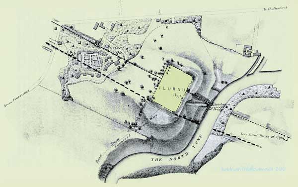
BROCOLITIA FORT The Fort at Carrawburgh added to the wall probably to fill the gap between CILURNUM and VIRCOVICIUM is an Infantry fort with no projection north of the line of the Wall. Added after the Vallum was established and built over it. The site was know before Horsley who first ascertained that its side walls made right angled junctions with the main Wall, that it had no northerly projection and that its vicus lay mainly to its western side and that close to it there was a well. The well was lost for a century and a half being discovered again by Clayton who excavated it . below the rubble that choked the top he found at once thirteen thousand, four hundred and eighty seven coins. many more were carried away by in a raid by the locals but in Clayton's find were four coins of gold, one hundred and eighty-four of silver and bronze coins covering three hundred years of Roman history. *4 The Fort itself has seen little excavation but from the state of its surface that much of its buildings remains. there was a bathhouse excavated by Clayton in 1873 similar to that at Cilurnum but nothing remains today. In the second century the garrison was the first cohort of Aquitanians, later the first cohort of the Cugeranians and in the third and fourth centuries the first cohort of Batavians.*5 Wide shots - Top - From the east and the line of the wall . Bottom - From south east click for bigger views
|
|||||||||||||||||||||||||||||||||||||||||||||||||||||||||||||||||||||||||||||||||||||||||||||||
 |
|||||||||||||||||||||||||||||||||||||||||||||||||||||||||||||||||||||||||||||||||||||||||||||||
 |
|||||||||||||||||||||||||||||||||||||||||||||||||||||||||||||||||||||||||||||||||||||||||||||||
 |
|||||||||||||||||||||||||||||||||||||||||||||||||||||||||||||||||||||||||||||||||||||||||||||||
 |
Temple of Mithras This temple at Carrawburgh is the finest found in Britain. ******************* Built by the soldiers based at Procolitia. Mithras was an Eastern sun-god, supposedly born from heaven. According to legend, he had captured and killed in a cave a bull, the first creature created on earth, and from the blood that flowed all manner of creatures gained new life. This doctrine of new life through sacrifice is one that brought Mithraism into conflict with Christianity. ********************** The temples were small, confined spaces, to represent the cave in which the bull-slaying episode took place. A large painting or sculpture of Mithras slaying the bull stood in front of three altars. It is clear that drama formed a part of the ceramonial; in one of the altars a series of pierced holes forms Mithras's crown, through which a lamp would have been shone at a high point of the ritual In addition, a curtain at the highest part of the temple would have been drawn back, allowing sunlight to stream in and illuminate the backdrop of Mithras slaying the bull, the triumph of light over darkness. The statues, altars, and wooden posts in the temple site now, are all casts of finds made during excavations in 1949. The originals and a full-scale reconstruction of the Carrawbrugh Mithraeum can be seen at the Great Museum of the North / Hancock in Newcastle upon Tyne. Roman buildings now seen as so drab were once brightly painted. This notetaken from the information sign provided by English Heritage at the Temple |
||||||||||||||||||||||||||||||||||||||||||||||||||||||||||||||||||||||||||||||||||||||||||||||
 |
|||||||||||||||||||||||||||||||||||||||||||||||||||||||||||||||||||||||||||||||||||||||||||||||
 |
References page 7 *1 David Divine - The North East Frontier of Rome 1969 Pg 105 *2 David Harrison - Along Hdrian's Wall 1956 Pg 83 *3David Divine - The North East Frontier of Rome 1969 Pg 106 *4David Divine - The North East Frontier of Rome 1969 Pg 108 *5 Frank Graham - The Roman Wall ComprehensiveHistory and Guide 1979 Pg 85 *6 Frank Graham - The Roman Wall ComprehensiveHistory and Guide 1979 Pg 72 * Carrawbrugh layout drawing - Frank Graham - The Roman Wall ComprehensiveHistory and Guide 1979 Pg 87 |
||||||||||||||||||||||||||||||||||||||||||||||||||||||||||||||||||||||||||||||||||||||||||||||
|
|||||||||||||||||||||||||||||||||||||||||||||||||||||||||||||||||||||||||||||||||||||||||||||||
 |
|||||||||||||||||||||||||||||||||||||||||||||||||||||||||||||||||||||||||||||||||||||||||||||||
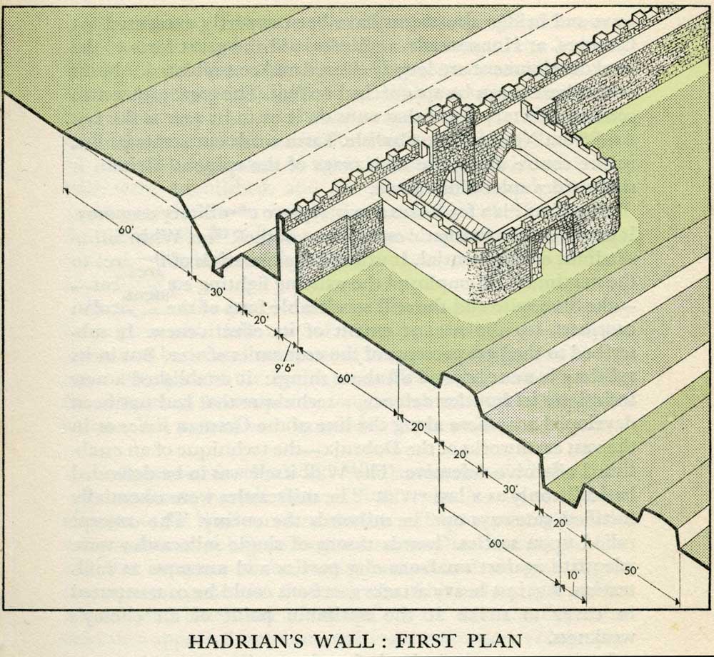 |
Milecastles
This first plan provided for a wall 10ft wide, 15ft 6 inches high and surmounted by a 6ft crenellation. to the north of this was a 20 ft berm, a standard fighting ditch 30ft by 13ft 6 inches, and a glacis composed of the spoil of the ditch, approximately 60ft in width. At each Roman mile was a milecastle with a north gate opening through the Wall, surmounted by a defensive turret and a south gate. In the original plan there were two barracks and the milecastle maintained a turret on either hand for the patrol garrison. South of the wall was the Vallum, a complex consisting of a 20 ft ditch with a wide bottom section and mounds composed of spoil to north and south. The wall was built to the design width only on the eastern slope. The Milecastles built before the change of plan had 10ft wings on either side. The curtain wall as finally built was substantially narrower and the join is indicated in the diagram. This information and the diagram taken from Richard Devine The Northwest Frontier of the Roman Empire Chap2 pg 27 |
||||||||||||||||||||||||||||||||||||||||||||||||||||||||||||||||||||||||||||||||||||||||||||||
 |
 |
||||||||||||||||||||||||||||||||||||||||||||||||||||||||||||||||||||||||||||||||||||||||||||||
