 |
||||||||||||||||||||||||||||||||||||||||||||||||||||||||||||||||||||||||||||||||||||||||||||
|
||||||||||||||||||||||||||||||||||||||||||||||||||||||||||||||||||||||||||||||||||||||||||||
|
|
||||||||||||||||||||||||||||||||||||||||||||||||||||||||||||||||||||||||||||||||||||||||||||
 |
Page II
Pons Aelius to Condercum |
 |
||||||||||||||||||||||||||||||||||||||||||||||||||||||||||||||||||||||||||||||||||||||||||
 |
||||||||||||||||||||||||||||||||||||||||||||||||||||||||||||||||||||||||||||||||||||||||||||
|
Milecastle 4 to 7 via Condercum Fort
From Milecastle 4 which is considered to have stood at the bottom of Pilgrim street in the area now occupied by All Saints Church the Wall began its journey West. This was the original beginning of the Wall, this was "Broad Wall" The length from Segedunum to Pons Aelii being "Narrow Wall". The Milecastles west are evenly spaced from the Bridge with a small exception near Benwell which confused Horsley . The exact site of the Bridge is established, however the fort location is less certain but considered to have been on the site of the later Castle. The Newcastle bridge was built by the Emperor Titus Aeluius Hadrianus around 120AD. Only two piers of Pons Aelii have been found but altars to Neptune and Oceanus have been recovered from the river. The Bridge was 735 feet in length and 16 feet in width, the piers had cutwaters up and downstream and there appears to have been ten piers and two abutments. William I used the Bridge on his way north and earlier Bede had crossed it to visit his bretheren in Monkchester the present Newcastle. The medieval bridge built on these foundations was eventually destroyed in 1248. The Site is now occupied by The Swing Bridge constructed 1868 -76 Roman Mile = 1620 yards = 0.92Mile = 1.48km
Start point for this page |
 |
|
||||||||||||||||||||||||||||||||||||||||||||||||||||||||||||||||||||||||||||||||||||||||||
 |
||||||||||||||||||||||||||||||||||||||||||||||||||||||||||||||||||||||||||||||||||||||||||||
|
Milecastle No.4 All Hallows Church
|
 |
|||||||||||||||||||||||||||||||||||||||||||||||||||||||||||||||||||||||||||||||||||||||||||
 |
 |
|||||||||||||||||||||||||||||||||||||||||||||||||||||||||||||||||||||||||||||||||||||||||||
|
Directly across the road from the swing bridge are Castle Steps and the steep climb to the southern portal of the 12 century Castle, thought to be the site of the small 2 acre fort, Pons Aelii. see the Richardson reconstruction below The wall was considered in 1929 to have skirted to the north of the fort through the grounds of the now St Nicholas Cathedral, having crossed Dean street approximately on the line of Low Bridge. Remains of the south face of the Wall were discovered in the fenced off area outside the Miners Institute near the entrance to the Lit & Phil. these were marked by red concrete. The Stephenson monument across the road almost certainly stands on the line of the wall. |
||||||||||||||||||||||||||||||||||||||||||||||||||||||||||||||||||||||||||||||||||||||||||||
 |
 |
|||||||||||||||||||||||||||||||||||||||||||||||||||||||||||||||||||||||||||||||||||||||||||
 |
||||||||||||||||||||||||||||||||||||||||||||||||||||||||||||||||||||||||||||||||||||||||||||
 |
||||||||||||||||||||||||||||||||||||||||||||||||||||||||||||||||||||||||||||||||||||||||||||
 |
||||||||||||||||||||||||||||||||||||||||||||||||||||||||||||||||||||||||||||||||||||||||||||
 |
||||||||||||||||||||||||||||||||||||||||||||||||||||||||||||||||||||||||||||||||||||||||||||
|
The Wall follows directly up Westgate Raod the line being under the right hand pavement. Westgate Road takes its name from the West Gate in Newcastle's medieval town wall. The Gateway was demolished in 1811 but a significant stretch of the town walls in the area known as Blackfriars can be seen. |
||||||||||||||||||||||||||||||||||||||||||||||||||||||||||||||||||||||||||||||||||||||||||||
 |
||||||||||||||||||||||||||||||||||||||||||||||||||||||||||||||||||||||||||||||||||||||||||||
|
The foot of Westgate Road >>>>>>>>>>>>>>
|
||||||||||||||||||||||||||||||||||||||||||||||||||||||||||||||||||||||||||||||||||||||||||||
 |
||||||||||||||||||||||||||||||||||||||||||||||||||||||||||||||||||||||||||||||||||||||||||||
|
Through the Westgate and up the hill this stretch of the road is famous for the numerous motorcycle shops and the accessory outlets that go with them. Witness the "Trooper" outside this one. >>>>>>>>>>>>>> |
||||||||||||||||||||||||||||||||||||||||||||||||||||||||||||||||||||||||||||||||||||||||||||
 |
||||||||||||||||||||||||||||||||||||||||||||||||||||||||||||||||||||||||||||||||||||||||||||
 |
 |
|||||||||||||||||||||||||||||||||||||||||||||||||||||||||||||||||||||||||||||||||||||||||||
 |
||||||||||||||||||||||||||||||||||||||||||||||||||||||||||||||||||||||||||||||||||||||||||||
|
Westgate road climbs up to the site of mile castle 5 thought to have been at the junction of Elswick Road and the West Road at the Junction known as the Big Lamp.
It proceeds as arrow straight as a Roman undertaking should. |
||||||||||||||||||||||||||||||||||||||||||||||||||||||||||||||||||||||||||||||||||||||||||||
 |
 |
|||||||||||||||||||||||||||||||||||||||||||||||||||||||||||||||||||||||||||||||||||||||||||
|
||||||||||||||||||||||||||||||||||||||||||||||||||||||||||||||||||||||||||||||||||||||||||||
|
The site of Milecastle 5 "the Big Lamp junction"
|
||||||||||||||||||||||||||||||||||||||||||||||||||||||||||||||||||||||||||||||||||||||||||||
 |
 |
|||||||||||||||||||||||||||||||||||||||||||||||||||||||||||||||||||||||||||||||||||||||||||
|
The wall line runs uphill again from the Elswick Road Junction and passes thejunction with Elswick Row and further on the General Hospital heading toword the site of Milecastle 6 before reaching CONDERCUM Fort at Benwell. |
||||||||||||||||||||||||||||||||||||||||||||||||||||||||||||||||||||||||||||||||||||||||||||
 |
THE VALLUM * Mile castle 6 in the absence of evidence, must have been at Benwell Grove. From here the Wall is accompanied by the Vallum. Horsley was first to notice that there was no Vallum between Newcastle and Wallsend and he stated emphatically that "there is not in all the space between Cousin's house (i.e. Wallsend) and Newcastle the least visage or appearance of Hadrian's Vallum or anything belonging to it." MacLaughlan first saw the Vallum " near the north end of Adrianople Street, where it is about 100 yards from the Wall in Westgate Street."Part of Elswick row was originall called Adrianople Street. The complicated and somtimes contradictory evidence about the place where the Vallum started can be read in the Northumberland County History. To get to Elswick Row the Vallum probably ran up from the River Tyne where it started near the Old Redheugh Bridge. From Elswick Row the Vallum kept a regular distance of about 100 yards from the Wall until Benwell Fort is reached. At one time it was clearly visible on the south of Westgate Road near the General hospital with the ditch also visible to the north of the road. The Vallum could be traced in several streets south of the road by cracks in buildings which were erected after the Vallum was filled in with light material. * Taken from "The Roman Wall" Frank Graham 1979 |
|||||||||||||||||||||||||||||||||||||||||||||||||||||||||||||||||||||||||||||||||||||||||||
 |
||||||||||||||||||||||||||||||||||||||||||||||||||||||||||||||||||||||||||||||||||||||||||||
 |
 |
 |
||||||||||||||||||||||||||||||||||||||||||||||||||||||||||||||||||||||||||||||||||||||||||
 |
||||||||||||||||||||||||||||||||||||||||||||||||||||||||||||||||||||||||||||||||||||||||||||
|
<<<<<< the site of Milecastle 6
The gateposts rendered in "Roman looking" Stones offer a clue to the folk who pass the Junction of Benwell Grove and the West Road |
||||||||||||||||||||||||||||||||||||||||||||||||||||||||||||||||||||||||||||||||||||||||||||
|
||||||||||||||||||||||||||||||||||||||||||||||||||||||||||||||||||||||||||||||||||||||||||||
 |
 |
|||||||||||||||||||||||||||||||||||||||||||||||||||||||||||||||||||||||||||||||||||||||||||
 |
CONDERCUM FORT
At the crest of what is now Benwell Hill, stood Condercum Fort and the remains of the Fort's Vallum crossing and a temple found within the area between the Vallum and the Wall are still to be seen. Condercum, the third station on the line, standing 400ft above the tide mark, the first of the major defence works of the "second plan" was a cavalry fort with one third extending north of the Wall. This had three wide cavalry gates. This extended area was used to house a reservoir in the 19th century while the remaining southern portion was built over with a housing estate in the 20th*1. In 1732 Horsley remarked that the fort at Benwell Hill remains distinct and clear. In 1751 the Newcastle - Carlisle military road was built through it following the main East-West street. By 1789 the area of the road to the north of the road had been cleared of stones and used for other purposes sufficient for this area to be planted with trees. Great conduits or sewers were discovered at the depth of about a yard and a half and were composed of large wrought stones. The east - west Gateways of the fort had been destroyed before 1751 and by the end of the 18th C all surface masonry was gone. *2 Bruce in 1851 observes that the site could be passed without noticing its position. Records of coins found at or near the Fort cover those of Emperors Nero to Gratian. |
|||||||||||||||||||||||||||||||||||||||||||||||||||||||||||||||||||||||||||||||||||||||||||
 |
||||||||||||||||||||||||||||||||||||||||||||||||||||||||||||||||||||||||||||||||||||||||||||
 |
||||||||||||||||||||||||||||||||||||||||||||||||||||||||||||||||||||||||||||||||||||||||||||
 |
 |
|||||||||||||||||||||||||||||||||||||||||||||||||||||||||||||||||||||||||||||||||||||||||||
|
The reservoir covering the northern third of the fort area is fronted over the brow of Benwell Hill by an ancient wall, one of many around this area with unknown vintage.
|
||||||||||||||||||||||||||||||||||||||||||||||||||||||||||||||||||||||||||||||||||||||||||||
|
THE VALLUM CROSSING AT BENWELL Before the area of the Fort was swallowed for all time by the reservoir in the north and a housing estate built on the remainder, the North of England and the Durham University Excavation Committees carried out a number of rescue missions. The southern angle towers were located and measured. parts of the granaries the barracks and stabling and much of the hospital were examined. Downhill from the south gate itself the location of the Vallum diversion was finally determined and the Vallum crossing, revetted at the sides with Roman ashlar and still carying the foundations of the arched gatewy that led across the Vallum into the military area, was consolidated as an ancient monument This crossing is unique it having been preserved and can be seen today. It is to be found in Denhill Park, accessable fron the West Road >>>>>>>>>>>>>> +(See the plans of the work carried out in 1926-29 below.) |
 |
|||||||||||||||||||||||||||||||||||||||||||||||||||||||||||||||||||||||||||||||||||||||||||
 |
||||||||||||||||||||||||||||||||||||||||||||||||||||||||||||||||||||||||||||||||||||||||||||
 |
||||||||||||||||||||||||||||||||||||||||||||||||||||||||||||||||||||||||||||||||||||||||||||
 |
The ROMAN TEMPLE
Set between the Fort and the line of the Vallum can be found in Broombridge Avenue. The Temple Altars, the originals of which are now among the Antiqities held in the The Great North Museum / Hancock, were dedicated to Antenociticus and to the deities of the the emperors by Aelius Vibius, a centuriuon of the Twentieth Legion. The emperors intended are Aurelius and Lucius Verus dating them to the period AD 161 and AD 169 *3 |
|||||||||||||||||||||||||||||||||||||||||||||||||||||||||||||||||||||||||||||||||||||||||||
 |
 |
|||||||||||||||||||||||||||||||||||||||||||||||||||||||||||||||||||||||||||||||||||||||||||
|
From CONDERCUM to milecastle 7 the Wall is on the level for about 400 yards.
The Wall line stays on the ridge of a spur, past where the end of Two Ball Lonnen and the Fox and Hounds Public House now exist the land to the south dropping sharply down to the valley of the River Tyne. Mile castle 7 sat where the where the Wall westward dropped sharply towards the valley of the Denton Burn. |
||||||||||||||||||||||||||||||||||||||||||||||||||||||||||||||||||||||||||||||||||||||||||||
 |
 |
 |
||||||||||||||||||||||||||||||||||||||||||||||||||||||||||||||||||||||||||||||||||||||||||
 |
 |
|||||||||||||||||||||||||||||||||||||||||||||||||||||||||||||||||||||||||||||||||||||||||||
|
||||||||||||||||||||||||||||||||||||||||||||||||||||||||||||||||||||||||||||||||||||||||||||
|
<<<<<< the site of Milecastle 7
Near the entrance to St. Cuthbert's House |
 |
|||||||||||||||||||||||||||||||||||||||||||||||||||||||||||||||||||||||||||||||||||||||||||
|
References for page2 *1 David Devine -The Northwest Frontier of Rome p93 *2 Madeleine Hope Dodds - A History of Northumberland Vol XIII pg 521 *3 J C Bruce - The Handbook to the Roman Wall 8th edition 1927 Pg 49 |
||||||||||||||||||||||||||||||||||||||||||||||||||||||||||||||||||||||||||||||||||||||||||||
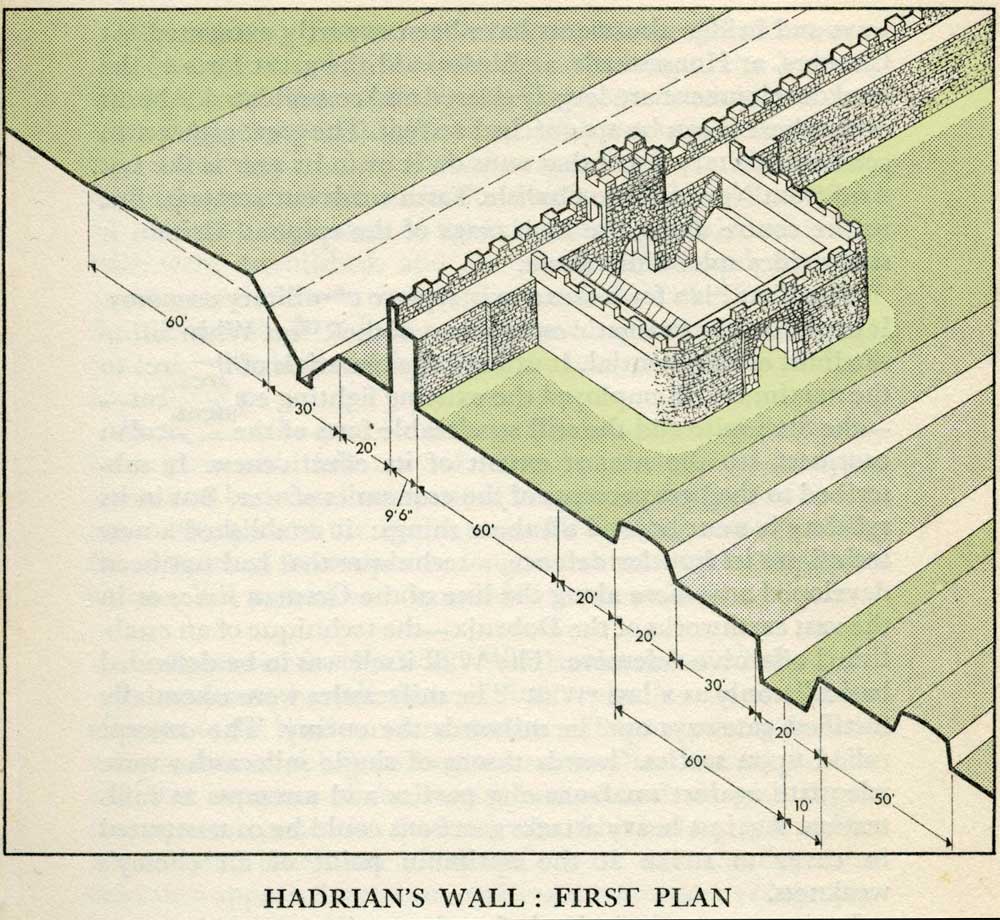 |
Milecastles
This first plan provided for a wall 10ft wide, 15ft 6 inches high and surmounted by a 6ft crenellation. to the north of this was a 20 ft berm, a standard fighting ditch 30ft by 13ft 6 inches, and a glacis composed of the spoil of the ditch, approximately 60ft in width. At each Roman mile was a milecastle with a north gate opening through the Wall, surmounted by a defensive turret and a south gate. In the original plan there were two barracks and the milecastle maintained a turret on either hand for the patrol garrison. South of the wall was the Vallum, a complex consisting of a 20 ft ditch with a wide bottom section and mounds composed of spoil to north and south. The wall was built to the design width only on the eastern slope. The Milecastles built before the change of plan had 10ft wings on either side. The curtain wall as finally built was substantially narrower and the join is indicated in the diagram. This information and the diagram taken from Richard Devine The Northwest Frontier of the Roman Empire Chap2 pg 27 |
|||||||||||||||||||||||||||||||||||||||||||||||||||||||||||||||||||||||||||||||||||||||||||
 |
||||||||||||||||||||||||||||||||||||||||||||||||||||||||||||||||||||||||||||||||||||||||||||
 |
||||||||||||||||||||||||||||||||||||||||||||||||||||||||||||||||||||||||||||||||||||||||||||
 |
||||||||||||||||||||||||||||||||||||||||||||||||||||||||||||||||||||||||||||||||||||||||||||
