 |
Page XVII
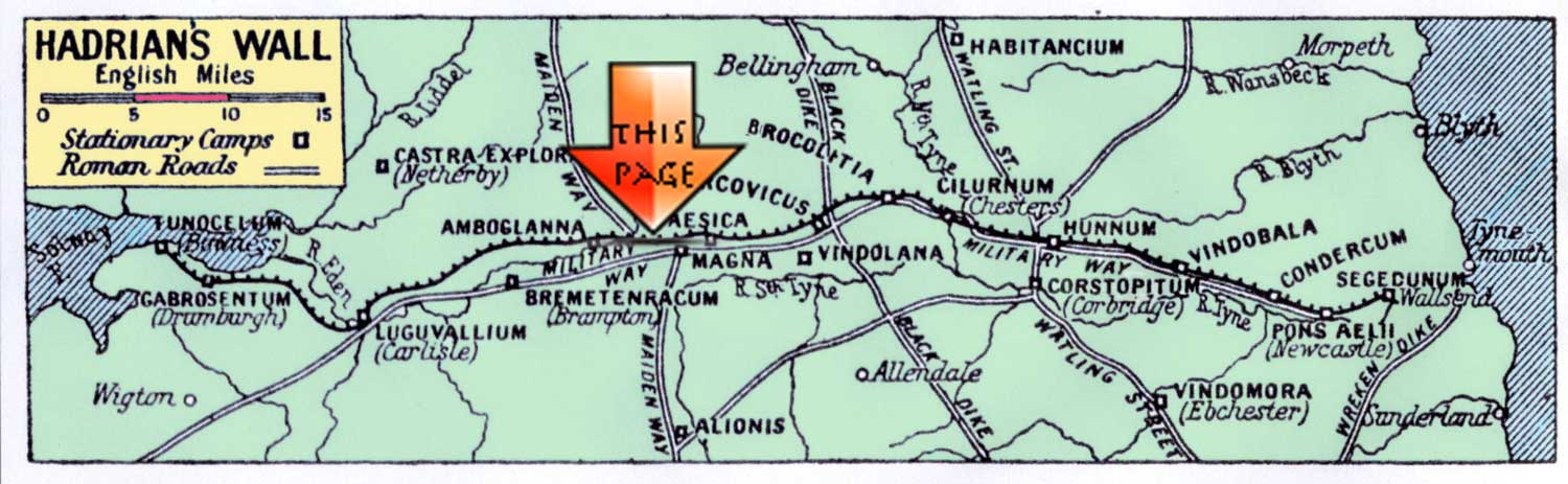
Dykesfield to Maia
Milecastles 73 to 80
|
 |
 |
||||||||||||||||||||||||||||||||||||||||||||||||||||||||||||||||||||||||
 |
|||||||||||||||||||||||||||||||||||||||||||||||||||||||||||||||||||||||||||
|
|
|
||||||||||||||||||||||||||||||||||||||||||||||||||||||||||||||||||||||||||
|
MC73 to MC80
From Milecastle 73 Roman Mile = 1620 yards = 0.92Mile = 1.48km
Start point for this page |
DRUMBURGH
Congavata The Name of the Fort CONGAVATA, from the Rudge Cup, Amiens skillet and Notitia *1Birley208 Leland (1539) first recorded the fort here and Camden sixty years later mentioned it. *2FG181 Location ABALLAVA 5.5 miles west of STANWIX It measures roughly 500ft north to south and 400ft east to west covering about five acres. .*2 FG 181 excavations in 1922 found only the east wall *Birley 208 The site is under the church and church yard and the field north of the road known as Monks Croft.*Birley208 Garrison; 2nd Century, at first a cavalry regiment (at one time ala I Tungorum) Later coh. Nervia Germanorum militaria; 3rd century a military cohort and cuneus Frisiorum, the latter succeeded by the numerus Maurorum Aurelianorum given by the Notitia as sole garrison. The Wall in this section was initially built in turf, and later converted into a stone wall, possibly in the second half of the second century AD. *6 EH |
 |
|||||||||||||||||||||||||||||||||||||||||||||||||||||||||||||||||||||||||
|
This Page is still in development
NBM Plans to continue beyond Stanwix summer 2017 sooner if possible |
|||||||||||||||||||||||||||||||||||||||||||||||||||||||||||||||||||||||||||
|
BOWNESS-ON-SOLWAY
MAIA The Name of the Fort MAIA, from the Rudge Cup, Amiens skillet is not shown in the Notitia *1Birley208 Leland (1539) first recorded the fort here and Camden sixty years later mentioned it. *2FG181 Location ABALLAVA 5.5 miles west of STANWIX It measures roughly 500ft north to south and 400ft east to west covering about five acres. .*2 FG 181 excavations in 1922 found only the east wall *Birley 208 The site is under the church and church yard and the field north of the road known as Monks Croft.*Birley208 Garrison; 2nd Century, at first a cavalry regiment (at one time ala I Tungorum) Later coh. Nervia Germanorum militaria; 3rd century a military cohort and cuneus Frisiorum, the latter succeeded by the numerus Maurorum Aurelianorum given by the Notitia as sole garrison. The Wall in this section was initially built in turf, and later converted into a stone wall, possibly in the second half of the second century AD. *6 EH |
 |
||||||||||||||||||||||||||||||||||||||||||||||||||||||||||||||||||||||||||
|
|||||||||||||||||||||||||||||||||||||||||||||||||||||||||||||||||||||||||||
|
^^^^^ From the Roman Wall by
J Collingwood Bruce |
|||||||||||||||||||||||||||||||||||||||||||||||||||||||||||||||||||||||||||
 |
|||||||||||||||||||||||||||||||||||||||||||||||||||||||||||||||||||||||||||
|
^^^^^The site of Milecastle 79
|
|||||||||||||||||||||||||||||||||||||||||||||||||||||||||||||||||||||||||||
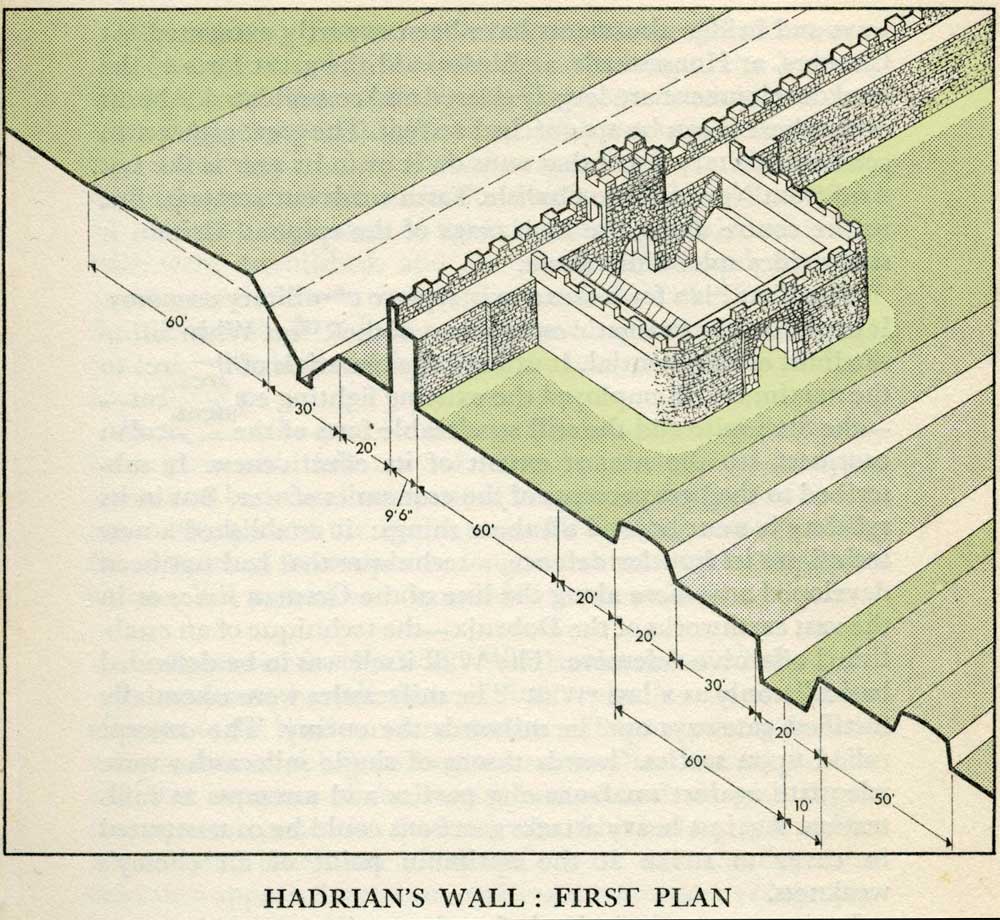 |
Milecastles
This first plan provided for a wall 10ft wide, 15ft 6 inches high and surmounted by a 6ft crenellation. to the north of this was a 20 ft berm, a standard fighting ditch 30ft by 13ft 6 inches, and a glacis composed of the spoil of the ditch, approximately 60ft in width. At each Roman mile was a milecastle with a north gate opening through the Wall, surmounted by a defensive turret and a south gate. In the original plan there were two barracks and the milecastle maintained a turret on either hand for the patrol garrison. South of the wall was the Vallum, a complex consisting of a 20 ft ditch with a wide bottom section and mounds composed of spoil to north and south. The wall was built to the design width only on the eastern slope. The Milecastles built before the change of plan had 10ft wings on either side. The curtain wall as finally built was substantially narrower and the join is indicated in the diagram. This information and the diagram taken from Richard Devine The Northwest Frontier of the Roman Empire Chap2 pg 27 |
||||||||||||||||||||||||||||||||||||||||||||||||||||||||||||||||||||||||||
|
|||||||||||||||||||||||||||||||||||||||||||||||||||||||||||||||||||||||||||
|
|||||||||||||||||||||||||||||||||||||||||||||||||||||||||||||||||||||||||||
|
References for Page 15 *1 David Devine -The Northwest Frontier of Rome p129/130 *2 Tony Wilmott + - Excavations of a Roman Fort on Hadrian's Wall and its successor settlements: 1987-92. English Heritage 1997 Archeological Report 14 *3 J C Bruce - The Handbook to the Roman Wall 8th edition 1927 Pg 49 *4 J C Bruce - The Handbook to the Roman Wall 10th edition 1947 Pg 184 *5 J C Bruce - The Handbook to the Roman Wall 10th edition 1947 Pg 183 *6 J C Bruce - The Handbook to the Roman Wall 10th edition 1947 Pg 184 Map:- Banna (Amboglanna) MacLaughlan 1857 Bust of Hadrian:- Muzeo, Nazionale, Naples |
|||||||||||||||||||||||||||||||||||||||||||||||||||||||||||||||||||||||||||
|
Milecastles
This first plan provided for a wall 10ft wide, 15ft 6 inches high and surmounted by a 6ft crenellation. to the north of this was a 20 ft berm, a standard fighting ditch 30ft by 13ft 6 inches, and a glacis composed of the spoil of the ditch, approximately 60ft in width. At each Roman mile was a milecastle with a north gate opening through the Wall, surmounted by a defensive turret and a south gate. In the original plan there were two barracks and the milecastle maintained a turret on either hand for the patrol garrison. South of the wall was the Vallum, a complex consisting of a 20 ft ditch with a wide bottom section and mounds composed of spoil to north and south. The wall was built to the design width only on the eastern slope. The Milecastles built before the change of plan had 10ft wings on either side. The curtain wall as finally built was substantially narrower and the join is indicated in the diagram. This information and the diagram taken from Richard Devine The Northwest Frontier of the Roman Empire Chap2 pg 27 |
||||||||||||||||||||||||||||||||||||||||||||||||||||||||||||||||||||||||||
 |
|||||||||||||||||||||||||||||||||||||||||||||||||||||||||||||||||||||||||||
|
|||||||||||||||||||||||||||||||||||||||||||||||||||||||||||||||||||||||||||
 |
|||||||||||||||||||||||||||||||||||||||||||||||||||||||||||||||||||||||||||