|
|
 |
|
Page III
Benwell to Heddon on the Wall
CONDERCUM Fort to MC 12
|
 |
|
|
|
|
|
|
|
 |
|
 |
|
From CONDERCUM
The Wall dives down into the valley of the Denton Burn. where there are remains of the Wall and Turret 7b. It climbs again over the ridge at Chapel House and gently turns slightly left and then arrow straight through Blucher Pit village and Walbottle. At Throckley another slight left turn to drive directly to the hilltop at Heddon where a considerable length of the Wall is to be seen. and where Milecastle 12 was located.
The siite of Milecastle 12 is not definitely determined but thought to be in the vicinity of Town Farm at Heddon on the wall.
At Heddon the "Hadrian's Way Walk " joins the Wall for the first time on the journey west having come from Wallsend along the River Tyne and climbing up from Newburn
Roman Mile = 1620 yards = 0.92Mile = 1.48km

Start point for this page
|
|
 |
|
Location
|
Milecastle
|
|
Segedunum to Pons Aelis
|
|
|
Pons Aelis to Condercum
|
|
|
Condercum to Heddon
|
|
|
Heddon to Harlow Hill
|
|
|
Harlow Hill to Portgate
|
|
|
Portgate to Chesters
|
|
|
Chesters to Brocolitia
|
|
|
Brocolitia to Vercovicivm
|
|
|
Vercovicivm to MC40
|
|
|
MC40 to Aesica
|
|
|
Aesica to Carvoran
|
|
|
Carvoran to Birdoswald
|
|
|
Birdoswald to Hare Hill
|
|
|
Hare Hill to Newton
|
|
|
Newton to Stanwix
|
|
|
Stanwix to Dykesfield
|
|
|
Dykesfield to Maia
|
|
|
|
|
|
|
|
|
|
|
|
|
|
|
|
 |
|
|
|
CONDERCUM FORT
At the crest of what is now Benwell Hill, stood Condercum Fort and the remains of the Fort's Vallum crossing and a temple found within the area between the Vallum and the Wall are still to be seen.
Condercum, the third station on the line, standing 400ft above the tide mark, the first of the major defense works of the second plan was a cavalry fort with one third extending north of the Wall. This had three wide cavalry gates. This extended area was used to house a reservoir in the 19th century while the remaining southern portion was built over with a housing estate in the 20th*1.
In 1732 Horsley remarked that the fort at Benwell Hill remains distinct and clear. In 1751 the Newcastle - Carlisle military road was built through it following the main East-West street. By 1789 the area of the road to the north of the road had been cleared of stones and used for other purposes sufficient for this area to be planted with trees. Great conduits or sewers were discovered at the depth of about a yard and a half and were composed of large wrought stones.
The east - west Gateways of the fort had been destroyed before 1751 and by the end of the 18th C all surface masonry was gone.
Bruce in 1851 observes that the site could be passed without noticing its position. *2
Records of coins found at or near the Fort cover those of Emperors Nero to Gratian.
|
|
|
 |
|
|
 |
|
|
 |
|
|
|
|
 |
|
|
|
|
|
|
|
|
|
From CONDERCUM to milecastle 7 the Wall is on the level for about 400 yards.
The Wall line stays on the ridge, past where the end of Two Ball Lonnen joins the West Road and where sits the Fox and Hounds Public House. The land to the south dropping sharply down to the valley of the River Tyne. Milecastle No. 7 sat where the where the Wall westward dropped sharply towards the valley of the Denton Burn.
|
|
|
|
|
|
|
 |
 |
 |
|
 |
|
<<<<<< the site of Milecastle 7
Near the entrance to St. Cuthbert's House
|
 |
|
|
|
|
Milecastle No.7 to No.8
The distance between milecastle No. 7 and the next one at West Denton, No. 8, about 2058 Yards (1182 metre), was ascertained in 1928-29 and is by far the longest milecastle interval known on the Wall. Ignorance of this fact led Horsley in 1732 to conclude that the spacing hereabouts had been reduced and to insert on his map an extra milecastle at the east side of the Denton Burn. This abnormal length is confirmed by the position of Denton hall Turret, No. 7b, at very nearly one third of the interval as usual.*3
The site of West Denton Milecastle No, 8 was examined in 1928.
*********
When the survey was prepared in 1926- 29 from Wallsend to Rudchester Burn considerable work was undertaken in the knowledge that future development was certain to obliterate the sites for all time.
Looking for the sites in this area today without recourse to the historical record is difficult. Would that I had been able to use Ordinance Survey Map references!
The sites were pretty much gone, to be fair in the 18th Century, when Horsley was taking more than an interest and all that useful "worked stone" had just been asking to be put to some use in the millenium before. That any of this exists for ourselves to cherish is nothing short of a miracle.
|
|
 |
|
|
 |
|
|
|
|
|
|
|
|
 |
|
 |
|
|
|
 |
|
The wall continues down to Denton Burn passing the junction at the south end of Silver Lonnen, a tiny unmarked piece of the Wall can be found in the forecourt of the filling station there.
About a hundred yards on at the Burn itself is another stretch of the Wall. The Burn is not to be seen here it having being taken underground some distance north and south of the main A69 road
|
|
|
|
 |
|
|
Crossing the Denton Burn.
Excavations well documented in Bruce's "Roman Wall" at Denton Burn uncovered the roman method of allowing streams to pass under their structures.
Where the Wall crossed Denton Burn a culvert carried the Burn through the wall. In 1867 Bruce published a woodcut showing the site.

"The circular arch is the drain which was formed when the road was made. The Roman channel is beneath. It consists of two massive stones laid parallel to each other, about two feet apart. The top was covered over by other large blocks, giving the conduit a height equivalent to its breadth. This seems to have been the usual way of allowing brooks to pass the Wall."
|
|
|
|
|
|
 |
|
|
|
|
Denton Hall Turret
Passing through where the library stands today and the line of houses beyond, the Wall is next seen in the stretch of wall into which is built Turret 7b this being some 400 yards west of the Burn.
The Turret is known as Denton Hall Turret in the records.

Photograph from time of the excavation in 1929
|
|
|
|
|
|
 |
|
 |
|
Denton Hall Turret
Turret 7b
The Excavation of this turret was undertaken on behalf of the Committee by Mr. E. B. Birley commencing in May 1929

The foundation of the wall near the Turret is about 10 ft 3 inches wide (3.13m). The south face is three courses high and the north two courses the final thickness being about 9 ft 4 inches (2.83m). the masonry is of a very massive character , many syones of the lowest course weighing more than a quarter of a ton each.
The small platform within was a base for the wooden stairway to the parapet walk.
|
|
|
|
|
|
|
 |
|
|
|
|
|
 |
|
|
The Vallum
South of this stretch of Wall the Vallum has been running parallel to it at a distance of about 100 yards. The road "West Vallum" being close to the Denton Hall turret
|
 |
|
|
|
 |
|
The Newcastle Western Bypass now cuts its wide swathe through the line of the Wall.
Until 1804 there had been a stretch of the wall some 200 yards long where the bypass now takes the A1 main road when it was removed to make way for tillage.
|
|
 |
|
|
|
|
|
|
 |
|
 |
|
West Denton
Beyond the bypass cutting as it makes it's way to the site of Milecastle No.8 the length of wall nominated "Denton West" sits at the side of the Main A69 Carlisle raod.
This like the Denton hall turret is in the custody of English Heritage
|
|
|
|
|
 |
|
|
|
 |
|
|
 |
|
|
Milecastle 8
Sited between the remains iof the Wall at denton West and the Sugley burn, the site of West Denton Milecastle 8 was examined in 1928 and proved to be a nutural mound upon which the Milecastle had stood. No masonry remained, but the site was established by characteristic occupation earth and pottery.
Sugley Burn
This burn like that at Denton was directed through the foundations of the wall using the identical technique using massive masonry it is now covered by the entrance drive to West Denton Hall.
|
|
|
The site of Milecastle 8 above
|
|
|
|
|
|
|
|
|
|
|
|
 |
|
 |
|
|
|
|
 |
|
|
 |
|
 |
|
 |
|
|
|
The Vallum
In the housing estate to the south of this stretch of wall the vallum has been left unbuilt upon. and can be traced through the steep sides of Sugley Burn.
As seen in the pictures above
|
|
Above: - The site of Milecastle 9
200 yards east of Blucher Pit
|
|
|
|
|
|
|
|
|
|
Milecastle 9 Chapel House
1602 yards west of milecastle 8 and the survey and excavations in 1928 found the sites of the two intervening turrets these were located in their normally expected positions at one third and two thirds distance
 . .
This milecastle is now gone. I cannot think why these remains were not secured in the manner of the Turret at Denton following the 1926-29 survey when, as can be seen from the drawings above, a considerable amount of the Milecastle remained.
The name is taken from Chapel House Farm.
|
|
|
|
|
|
|
 |
|
A few hundred yards down the road as one enters Blucher Pit Village there remains a trace of the Defensive Ditch.
|
|
|
|
|
|
|
|
|
|
 |
|
|
|
|
 |
|
From Milecastle .9 the Wall line now continues along through Walbottle (The name anciently meant dwelling place on the wall)
The Vallum can be seen in the fields to the south and at the Walbottle Campus grounds a length of the Defensive Ditch (The Fosse) sits behind the hedge.
Beyond the campus at the top of the hill is the site of Milecastle No. 10
|
|
|
|
|
|
|
|
|
|
 |
 |
 |
|
 |
|
|
 |
|
 |
|
|
|
|
|
Dene House - The site of Milecastle 10
|
|
|
|
|
|
|
|
From Milecastle 10 The wall crossed the stream running through Walbottle Dene and traces of the Vallum can be faintly seen though the woodland on the banks of the Dene.
The line of the Wall takes a slight left turn and heads up through Throckley on the way to Heddon on the Wall.
|
|
|
|
|
|
|
|
 |
 |
 |
|
|
|
 |
|
|
 |
|
|
 |
|
|
|
 |
|
|
|
|
|
<<<<<<<<<<<<<<<<<- The site of Milecastle 11
Throckley Bank Top
|
|
|
|
|
 |
From Milecastle 11 the Wall continues up what is described in some volumes as the Great Hill.
On reaching the crest, Heddon on the Wall is seen ahead with a length of the Wall some 100 yards long in the field to the left of the raod. This impresive remainder stands at best 6 courses high on the south and 4 on the north.
The Vallum
This can be seen in the fields to the south on the approach to the crest and to the south at the crest. guided by David Harrison in his book "Along Hadrian's Wall" 1956 Pan. He writes talking of Heddon.
"........... Just before this, at the top of the hill, the Vallum is cut through the living rock and the marks of the Roman picks are plainly visible. ,,,,,,,,,,,,,,,,,,, up the hillock and through some rather troublsome gorse and you will find yourself decending into the Vallum . It is worth turning aside to see."
I can vouch for the Gorse it is now grown to massive proportions and there is no ready access to the area he mentions.
I have however taken the Photographs shown here for the record
|
|
|
 |
|
|
|
|
|
|
 |
|
 |
|
|
 |
|
 |
|
 |
|
 |
 |
|
 |
|
|
|
|
 |
|
The Kiln
One of interesting features in this length of the Broad Wall , given to the Society of antiquities of Newcastle by Sir James Knott Bart. in 1924, is the curious circular chamber built into the thickness of the Wall. This was discovered by John Clayton about 1883. It is of post-Roman date and is probably the base of a Medieval kiln.
Coin Hoards
During the making of the road in 1752 the workmen "found a great number of curious coins and medals in the ruins of the old wall near Heddon. They had been deposited in wooden boxes which were almost decayed........ Some were of silver but he most part copper......"
Another coin group described as 'a hoard' from Heddon on the Wall is generally understood to have been found about 1820, and 31 of these, covering the period A.D. 286-408 were presented to the Society of Antiquities of Newcastle in 1856.
Milecastle 12
There was a search made for Milecastle 12 in 1928 and again in 1929 without success. It had apparently been entirely obliterated. Its position by measurement should be on Town Farm just opposite the Farmhouse, about 1620 yards from the assumed position of Milecastle No. 11. The distance to the next Milecastle west of Rudchester Burn is also about 1620 yards.*2
|
|
The site of Milecastle 12
Town Farm. Heddon on the Wall
|
|
|
|
 |
|
|
References for Page 3
*1 Issued by Northumberland County History Committee -The Roman Frontier from Wallsend to Rudchester Burn 1930 pg 537
*2 J C Bruce - The Handbook to the Roman Wall 8th edition 1927 Pg 49
*3 Issued by Northumberland County History Committee -The Roman Frontier from Wallsend to Rudchester Burn 1930 pg 528
|
|
|
|
|
 |
Milecastles
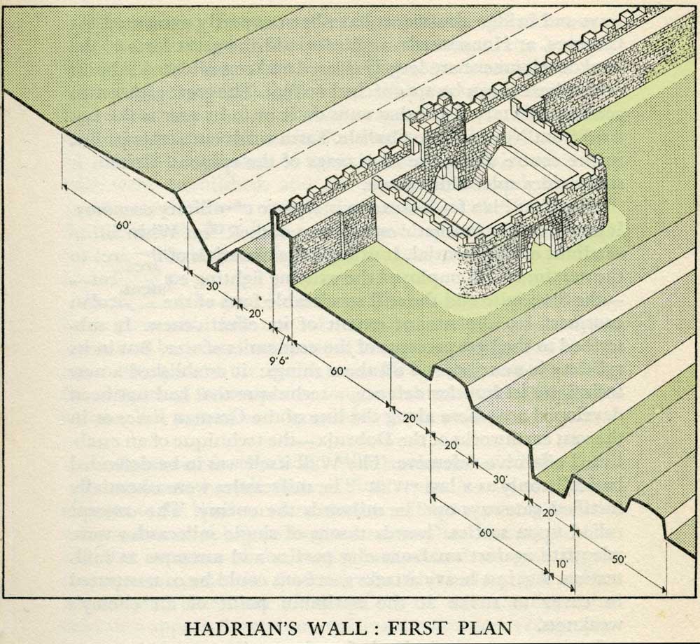
This first plan provided for a wall 10ft wide, 15ft 6 inches high and surmounted by a 6ft crenellation. to the north of this was a 20 ft berm, a standard fighting ditch 30ft by 13ft 6 inches, and a glacis composed of the spoil of the ditch, approximately 60ft in width.
At each Roman mile was a milecastle with a north gate opening through the Wall, surmounted by a defensive turret and a south gate. In the original plan there were two barracks and the milecastle maintained a turret on either hand for the patrol garrison.
South of the wall was the Vallum, a complex consisting of a 20 ft ditch with a wide bottom section and mounds composed of spoil to north and south. The wall was built to the design width only on the eastern slope. The Milecastles built before the change of plan had 10ft wings on either side. The curtain wall as finally built was substantially narrower and the join is indicated in the diagram.
This information and the diagram taken from Richard Devine The Northwest Frontier of the Roman Empire Chap2 pg 27
|
|
|
|
|
|
|
|
|
 |
|
 |
|
|
 |
|
|
|
|
|
|
|
|
|
|
|
|
|
|
|
|
|
|
|
|
|
|
|
|
|
|
|
|
|
|
|
|
|
|
|
|
|
|
|
|
|
|
|
|
|
|
|
|
|
|
|
|
|
|
|
|
|
|
|
|
|
|
|
|
|
|
|
|
|
|
|
|
|
|
|


