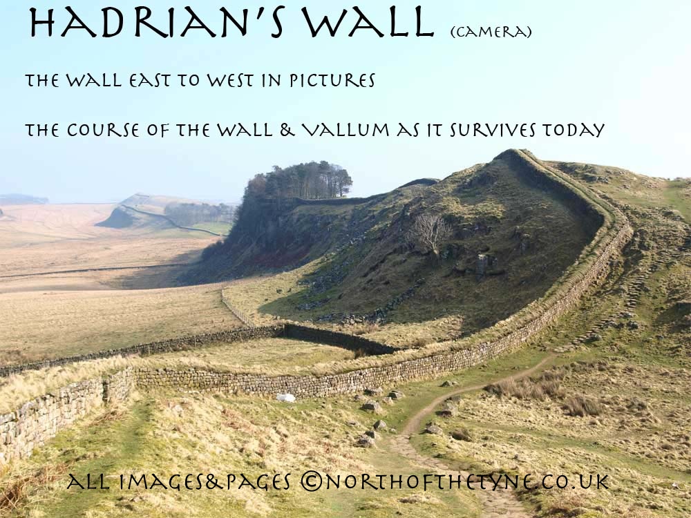
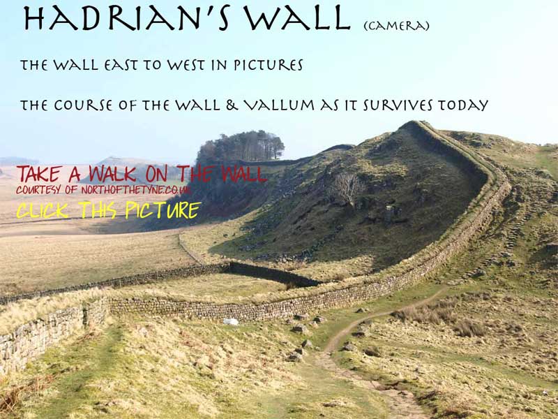
 |
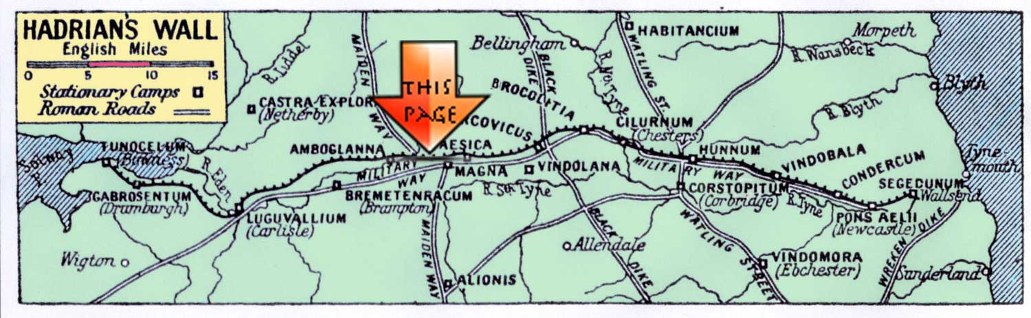
Page XVI Newton to Stanwix
Milecastles 58 to 66
|
 |
 |
||||||||||||||||||||||||||||||||||||||||||||||||||||||||||||||||||||||||||||||||||
 |
|||||||||||||||||||||||||||||||||||||||||||||||||||||||||||||||||||||||||||||||||||||
|
MC58 to MC66
From Milecastle 58 at Newton the Wall makes its way through Old Wall, Bleatarn Farm and Wall Head to Walby before being crossed by the M6 Motorway, The Wall moves on to the modern City of Carlisle. and the fort of STANWIX (PETRIANA). ******************* Logic ends at the Irthing bridgehead. For the fifty miles of the Wall from the Tyne crossing the Architects of the First Plan sought every military advantage in a somewhat unhelpful terrain. For the fifteen miles from the Coesike (MC 33) they won, boldly and resolutely, every particular degree of military strength from the precipituos escarpment of the Great Whin Sill. For the five miles west of the Irthing Bridgehead (MC 49) they planned the Wall along the crest of another escarpment - but the escarpment faced the wrong way, south ! *1(129) From the Irthing to the Eden crossing, the Wall is anomalous. *1 (138) In other words it deviates from the rules. Roman Mile = 1620 yards = 0.92Mile = 1.48km
Start point for this page |
|||||||||||||||||||||||||||||||||||||||||||||||||||||||||||||||||||||||||||||||||||||
 |
|
||||||||||||||||||||||||||||||||||||||||||||||||||||||||||||||||||||||||||||||||||||
|
^^^^^The site of Milecastle 58
NY49786258 exact unknown |
 |
||||||||||||||||||||||||||||||||||||||||||||||||||||||||||||||||||||||||||||||||||||
 |
|||||||||||||||||||||||||||||||||||||||||||||||||||||||||||||||||||||||||||||||||||||
 |
|||||||||||||||||||||||||||||||||||||||||||||||||||||||||||||||||||||||||||||||||||||
 |
 |
||||||||||||||||||||||||||||||||||||||||||||||||||||||||||||||||||||||||||||||||||||
 |
|||||||||||||||||||||||||||||||||||||||||||||||||||||||||||||||||||||||||||||||||||||
 |
 |
||||||||||||||||||||||||||||||||||||||||||||||||||||||||||||||||||||||||||||||||||||
|
|||||||||||||||||||||||||||||||||||||||||||||||||||||||||||||||||||||||||||||||||||||
 |
|||||||||||||||||||||||||||||||||||||||||||||||||||||||||||||||||||||||||||||||||||||
 |
|||||||||||||||||||||||||||||||||||||||||||||||||||||||||||||||||||||||||||||||||||||
 |
|||||||||||||||||||||||||||||||||||||||||||||||||||||||||||||||||||||||||||||||||||||
 |
 |
||||||||||||||||||||||||||||||||||||||||||||||||||||||||||||||||||||||||||||||||||||
 |
 |
||||||||||||||||||||||||||||||||||||||||||||||||||||||||||||||||||||||||||||||||||||
|
The site of Milecastle 59
NY4854 6174 Excavated in 1894 Geo 1981 |
|
||||||||||||||||||||||||||||||||||||||||||||||||||||||||||||||||||||||||||||||||||||
 |
|||||||||||||||||||||||||||||||||||||||||||||||||||||||||||||||||||||||||||||||||||||
 |
|||||||||||||||||||||||||||||||||||||||||||||||||||||||||||||||||||||||||||||||||||||
 |
|||||||||||||||||||||||||||||||||||||||||||||||||||||||||||||||||||||||||||||||||||||
 |
 |
||||||||||||||||||||||||||||||||||||||||||||||||||||||||||||||||||||||||||||||||||||
 |
 |
||||||||||||||||||||||||||||||||||||||||||||||||||||||||||||||||||||||||||||||||||||
 |
|||||||||||||||||||||||||||||||||||||||||||||||||||||||||||||||||||||||||||||||||||||
 |
|||||||||||||||||||||||||||||||||||||||||||||||||||||||||||||||||||||||||||||||||||||
|
|||||||||||||||||||||||||||||||||||||||||||||||||||||||||||||||||||||||||||||||||||||
|
Uncertain
but NY4719 6140 offered The site of Milecastle 60 |
|||||||||||||||||||||||||||||||||||||||||||||||||||||||||||||||||||||||||||||||||||||
 |
 |
 |
|||||||||||||||||||||||||||||||||||||||||||||||||||||||||||||||||||||||||||||||||||
 |
|||||||||||||||||||||||||||||||||||||||||||||||||||||||||||||||||||||||||||||||||||||
 |
|||||||||||||||||||||||||||||||||||||||||||||||||||||||||||||||||||||||||||||||||||||
 |
 |
 |
|||||||||||||||||||||||||||||||||||||||||||||||||||||||||||||||||||||||||||||||||||
|
|||||||||||||||||||||||||||||||||||||||||||||||||||||||||||||||||||||||||||||||||||||
|
At the road junction near to Wall Head farm
NY4558 6088 The site of Milecastle 61 |
|
||||||||||||||||||||||||||||||||||||||||||||||||||||||||||||||||||||||||||||||||||||
 |
 |
||||||||||||||||||||||||||||||||||||||||||||||||||||||||||||||||||||||||||||||||||||
|
From here to the crossing of the A689 road the OS Explorer Map No315 advises the wall line is the right hand hedgerow.
|
|||||||||||||||||||||||||||||||||||||||||||||||||||||||||||||||||||||||||||||||||||||
.jpg) |
500m east of Walby
Long axis NY4430 6049 The site of Milecastle 62 <<<<<<<<<< |
||||||||||||||||||||||||||||||||||||||||||||||||||||||||||||||||||||||||||||||||||||
|
|||||||||||||||||||||||||||||||||||||||||||||||||||||||||||||||||||||||||||||||||||||
 |
 |
 |
|||||||||||||||||||||||||||||||||||||||||||||||||||||||||||||||||||||||||||||||||||
|
The Wall line turns S/West as it passes through Walby Farm
|
|||||||||||||||||||||||||||||||||||||||||||||||||||||||||||||||||||||||||||||||||||||
 |
 |
 |
|||||||||||||||||||||||||||||||||||||||||||||||||||||||||||||||||||||||||||||||||||
 |
|||||||||||||||||||||||||||||||||||||||||||||||||||||||||||||||||||||||||||||||||||||
 |
800m SW of Walby
NY4315 5973 Walby West The site of Milecastle 63 <<<<<<<<<< |
||||||||||||||||||||||||||||||||||||||||||||||||||||||||||||||||||||||||||||||||||||
|
|||||||||||||||||||||||||||||||||||||||||||||||||||||||||||||||||||||||||||||||||||||
 |
 |
This track is shown on the OS 315 however using it is discouraged it is overgrown and littered with obstacles The Wall line as as advised before is down the right hand side all the way to where it is crossed by the A689 |
|||||||||||||||||||||||||||||||||||||||||||||||||||||||||||||||||||||||||||||||||||
 |
 |
||||||||||||||||||||||||||||||||||||||||||||||||||||||||||||||||||||||||||||||||||||
 |
Beyond the A689 the Wall Line is along the picket fence on the right |
||||||||||||||||||||||||||||||||||||||||||||||||||||||||||||||||||||||||||||||||||||
 |
 |
||||||||||||||||||||||||||||||||||||||||||||||||||||||||||||||||||||||||||||||||||||
 |
|||||||||||||||||||||||||||||||||||||||||||||||||||||||||||||||||||||||||||||||||||||
 |
|||||||||||||||||||||||||||||||||||||||||||||||||||||||||||||||||||||||||||||||||||||
|
The Wall line is crossed by the M6 Motorway
|
|||||||||||||||||||||||||||||||||||||||||||||||||||||||||||||||||||||||||||||||||||||
|
This Page is still in development
NBM 2 MC to complete this page May 2018 ************** |
|||||||||||||||||||||||||||||||||||||||||||||||||||||||||||||||||||||||||||||||||||||
|
^^^^^^^^^^^
800m SW of Walby NY4177 5874 Drawdykes The site of Milecastle 64 In a former Army Camp |
|||||||||||||||||||||||||||||||||||||||||||||||||||||||||||||||||||||||||||||||||||||
|
|||||||||||||||||||||||||||||||||||||||||||||||||||||||||||||||||||||||||||||||||||||
|
Stanwix
UXELODUNUM The Name of the Fort The fort was called Petrianis in the Notitia Dignitatum, but on the Ravenna Cosmography it is called Uxellodamo, whilst on the Rudge Cup and the Amiens Skillet it is called Uxelodum and Uxelodunum, respectively. The name Petrianis comes from the cohort that was stationed there. Uxelodunum, which appears to be a latinisation of a Celtic toponym, is thought to mean High Fort. It is thus likely that the name Petriana was a scribal error which confused the fort's name and the occupying unit, and that the fort's true name was Uxelodunum..*2Wiki Named for the ala Augusta Gallorum Pertiana bis torquata millitaria civiem Romanorum - the senior regiment of cavalry in the province of Britain. .*3 (136) This Regiment, 1000 strong, twice decorated with torques for valour and made Roman citizens..*4 FG176 Location 8 Miles west of CAMBOGLANNAand 5.5 miles east of ABALLAVA It stands on a natural platform above the River Eden. Uxelodunum was excavated in 1939 which traced the Wall line, a granary and barracks. the size of the Fort was found to be 700 ft from east to west and 580 ft from north to south. making it the largest and Most important fort on the Wall. .*5 FG 175 The Wall in this section was initially built in turf, and later converted into a stone wall, possibly in the second half of the second century AD. A length of the stone-built Wall was found in excavations by Simpson in 1932 within the playground of Stanwix Primary School. *6 EH |
 |
||||||||||||||||||||||||||||||||||||||||||||||||||||||||||||||||||||||||||||||||||||
| STANWIX FORT location in North East Carlisle | |||||||||||||||||||||||||||||||||||||||||||||||||||||||||||||||||||||||||||||||||||||
|
|||||||||||||||||||||||||||||||||||||||||||||||||||||||||||||||||||||||||||||||||||||
|
References for Page 15 *1 David Devine -The Northwest Frontier of Rome p129/130 *2 Tony Wilmott + - Excavations of a Roman Fort on Hadrian's Wall and its successor settlements: 1987-92. English Heritage 1997 Archeological Report 14 *3 J C Bruce - The Handbook to the Roman Wall 8th edition 1927 Pg 49 *4 J C Bruce - The Handbook to the Roman Wall 10th edition 1947 Pg 184 *5 J C Bruce - The Handbook to the Roman Wall 10th edition 1947 Pg 183 *6 J C Bruce - The Handbook to the Roman Wall 10th edition 1947 Pg 184 Map:- Banna (Amboglanna) MacLaughlan 1857 Bust of Hadrian:- Muzeo, Nazionale, Naples |
|||||||||||||||||||||||||||||||||||||||||||||||||||||||||||||||||||||||||||||||||||||
 |
Milecastles
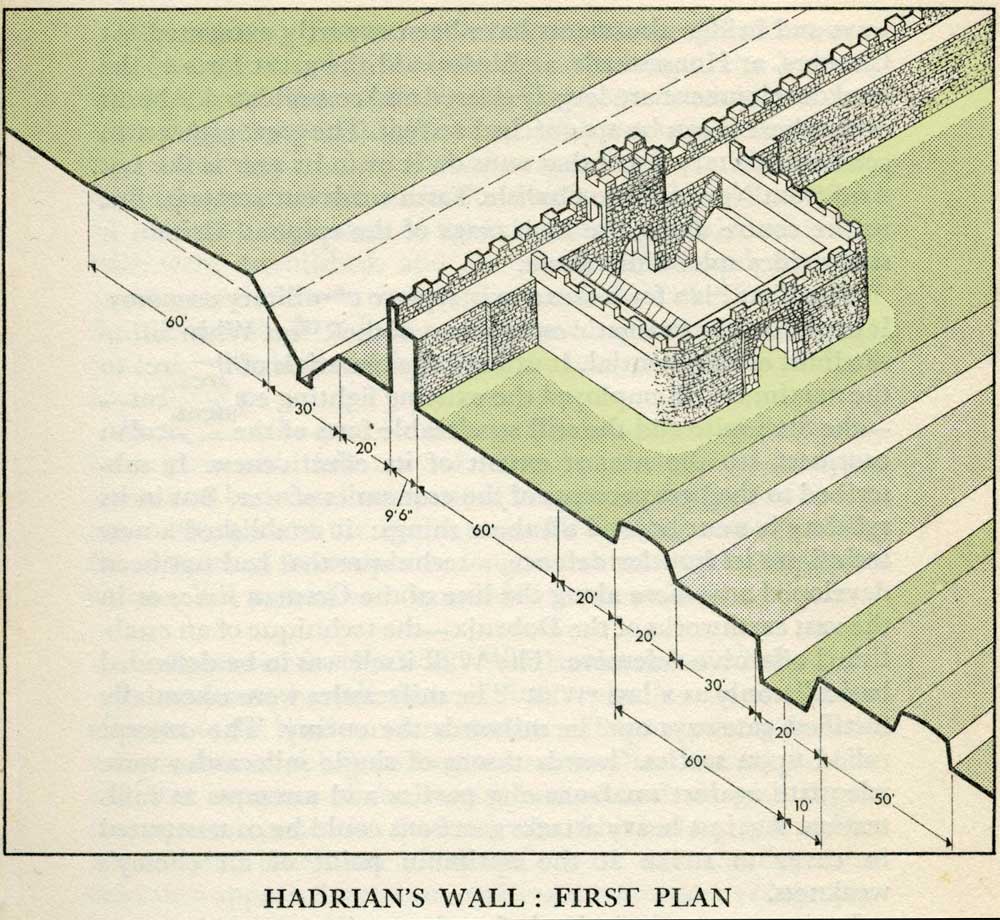
This first plan provided for a wall 10ft wide, 15ft 6 inches high and surmounted by a 6ft crenellation. to the north of this was a 20 ft berm, a standard fighting ditch 30ft by 13ft 6 inches, and a glacis composed of the spoil of the ditch, approximately 60ft in width. At each Roman mile was a milecastle with a north gate opening through the Wall, surmounted by a defensive turret and a south gate. In the original plan there were two barracks and the milecastle maintained a turret on either hand for the patrol garrison. South of the wall was the Vallum, a complex consisting of a 20 ft ditch with a wide bottom section and mounds composed of spoil to north and south. The wall was built to the design width only on the eastern slope. The Milecastles built before the change of plan had 10ft wings on either side. The curtain wall as finally built was substantially narrower and the join is indicated in the diagram. This information and the diagram taken from Richard Devine The Northwest Frontier of the Roman Empire Chap2 pg 27 |
||||||||||||||||||||||||||||||||||||||||||||||||||||||||||||||||||||||||||||||||||||
 |
|||||||||||||||||||||||||||||||||||||||||||||||||||||||||||||||||||||||||||||||||||||
|
|||||||||||||||||||||||||||||||||||||||||||||||||||||||||||||||||||||||||||||||||||||
 |
|||||||||||||||||||||||||||||||||||||||||||||||||||||||||||||||||||||||||||||||||||||
|
|||||||||||||||||||||||||||||||||||||||||||||||||||||||||||||||||||||||||||||||||||||
|
|||||||||||||||||||||||||||||||||||||||||||||||||||||||||||||||||||||||||||||||||||||
|
|||||||||||||||||||||||||||||||||||||||||||||||||||||||||||||||||||||||||||||||||||||