|
Page XI
Aesica Fort to Caravoran
Milecastles 43 to 46
|
 |
 |
||||||||||||||||||||||||||||||||||||||||||||||||||||||||||||||||||||||||||||||||||||||||||||||||||||||||||||||||||||
 |
||||||||||||||||||||||||||||||||||||||||||||||||||||||||||||||||||||||||||||||||||||||||||||||||||||||||||||||||||||||
 |
||||||||||||||||||||||||||||||||||||||||||||||||||||||||||||||||||||||||||||||||||||||||||||||||||||||||||||||||||||||
 |
|
|||||||||||||||||||||||||||||||||||||||||||||||||||||||||||||||||||||||||||||||||||||||||||||||||||||||||||||||||||||
|
AESICA TO CARVORAN
From Milecastle 43 within the surrounds of Aesica Fort the Wall makes its way along the ridge of the Whin Sill past Cockmount Hill and over Walltown Crags to Milecastle 46 on the Wall north of the Stanegate Fort Carvoran (MAGNA) where the Roman Army Museum is now situated. Roman Mile = 1620 yards = 0.92Mile = 1.48km
|
 |
|
||||||||||||||||||||||||||||||||||||||||||||||||||||||||||||||||||||||||||||||||||||||||||||||||||||||||||||||||||||
|
AESICA
Beyond Cawfields Quarry and across the Haltwhistle burn. the Wall makes its way up to "Greatchesters" so named in latter-day England. not because it was a greater fort than the other "Chesters" at Chollerford but because it's Walls stood for longer and were taller than those more conveniently robbed, and protected that bit longer by the remote location. In 1724 Alexander Gordon described the Structure as standing "thirteen feet high" The stones of this fort have since gone on to provide for farm buildings and field walls. Greatchesters The Amiens skillet calls it "Esica" as does the Ravenna list. The Notilia calls it "AESICA" An area covered of about three acres. It is unusual in having a duplication of Ditches in its surrounds. Bruce, reminds us of an earlier discovery of an Aquaduct traced from the Caw Burn some two miles distant from the fort, over a distance of six miles, to come within a few hundred yards. There has been much speculation through the years regarding AESICA's place in the scheme of the wall. The debate centering around the north wall of the Fort and its integration and conjunction with the Defensive Wall at the NW corner. * "Everything about the northwest corner of Greatchesters suggests that, as at Housesteads, it was built in the certainty that the Broad wall was abandoned , in the belief that the fort would have to stand alone, and before the necessity with the Narrow wall was considered. (*D Devine: NW Frontier of Rome |
||||||||||||||||||||||||||||||||||||||||||||||||||||||||||||||||||||||||||||||||||||||||||||||||||||||||||||||||||||||
 |
||||||||||||||||||||||||||||||||||||||||||||||||||||||||||||||||||||||||||||||||||||||||||||||||||||||||||||||||||||||
 |
||||||||||||||||||||||||||||||||||||||||||||||||||||||||||||||||||||||||||||||||||||||||||||||||||||||||||||||||||||||
 |
||||||||||||||||||||||||||||||||||||||||||||||||||||||||||||||||||||||||||||||||||||||||||||||||||||||||||||||||||||||
|
Milecastle 43 and AESICA
Milecastle 43 was already partly erected in accordance with the First Plan and once more the plan itself was ignored, the possibility of an eventual conjunction with the wall entirely disregarded. Here at Greatchesters to have built (the fort north wall) north of the Broad Foundation would have meant building on the berm between the Broad Foundation and the Fighting Ditch, and therefore on unstable ground. The substitute line selected by the fort's engineers was immediatly behind the Broad Foundation and ran directly through the east and west walls of the milecastle which was levelled to take it. * |
||||||||||||||||||||||||||||||||||||||||||||||||||||||||||||||||||||||||||||||||||||||||||||||||||||||||||||||||||||||
|
The AESICA brooch
The Aesica Brooch is one of the most famous Celtic artefacts from Roman Britain. It was found in September 1894 during the excavation of the west guard chamber of the south gate of Great Chesters fort (Aesica) on Hadrian's Wall. Unfortunately, no archaeologist was on site at the time and the brooch, with the rest of the hoard of gold, silver and gilt jewellery found at the same time, simply fell out of the section. The brooch is of gilded bronze and is cast in two parts which slot together: the upper part consists of the curved bow and the square headplate, the disc and fantail foot form the lower part. The brooch is decorated all over by swirling designs of trumpet scrolls in relief within a beaded border. It is about 4" (100mm) in length There has been much discussion about this brooch over the years but it is now generally agreed that it was a product of a north of England Celtic workshop, possibly in Yorkshire, around 70 or 80 AD. Typologically, it can be seen as a development of the Continental thistle brooch, which can be found throughout the Rhineland and Gaul with some examples in Pannonia. Although parallels of the form and the decoration can be identified in Britain the Aesica brooch remains unique in bringing all the elements together in one piece of jewellery. TW museums information |
||||||||||||||||||||||||||||||||||||||||||||||||||||||||||||||||||||||||||||||||||||||||||||||||||||||||||||||||||||||
 |
||||||||||||||||||||||||||||||||||||||||||||||||||||||||||||||||||||||||||||||||||||||||||||||||||||||||||||||||||||||
 |
 |
|||||||||||||||||||||||||||||||||||||||||||||||||||||||||||||||||||||||||||||||||||||||||||||||||||||||||||||||||||||
 |
 |
|||||||||||||||||||||||||||||||||||||||||||||||||||||||||||||||||||||||||||||||||||||||||||||||||||||||||||||||||||||
 |
 |
|||||||||||||||||||||||||||||||||||||||||||||||||||||||||||||||||||||||||||||||||||||||||||||||||||||||||||||||||||||
|
<<<<<The site of Milecastle 43
Built over by the Fort Builders of Aesica |
 |
|||||||||||||||||||||||||||||||||||||||||||||||||||||||||||||||||||||||||||||||||||||||||||||||||||||||||||||||||||||
|
The line of the wall proceeds westward toward Cockmount Hill built on the foundations of a narrow wall, the Broad foundations having been rejected.
The Ditch can be seen faintly on this slope |
||||||||||||||||||||||||||||||||||||||||||||||||||||||||||||||||||||||||||||||||||||||||||||||||||||||||||||||||||||||
 |
 |
|||||||||||||||||||||||||||||||||||||||||||||||||||||||||||||||||||||||||||||||||||||||||||||||||||||||||||||||||||||
 |
<<<<The north end of Cockmouth Farm sits astride the line of the wall
|
|||||||||||||||||||||||||||||||||||||||||||||||||||||||||||||||||||||||||||||||||||||||||||||||||||||||||||||||||||||
 |
||||||||||||||||||||||||||||||||||||||||||||||||||||||||||||||||||||||||||||||||||||||||||||||||||||||||||||||||||||||
 |
 |
|||||||||||||||||||||||||||||||||||||||||||||||||||||||||||||||||||||||||||||||||||||||||||||||||||||||||||||||||||||
|
West of Cockmouth Farm a small wood contains a grass covered and mossy stretch of Wall
|
||||||||||||||||||||||||||||||||||||||||||||||||||||||||||||||||||||||||||||||||||||||||||||||||||||||||||||||||||||||
 |
 |
West of the wood the round stone at the first farm gateway is shown on some guides as a Roman Milestone.
Did they need milestones with the regularity of the milecastles and turrets ! |
||||||||||||||||||||||||||||||||||||||||||||||||||||||||||||||||||||||||||||||||||||||||||||||||||||||||||||||||||||
 |
||||||||||||||||||||||||||||||||||||||||||||||||||||||||||||||||||||||||||||||||||||||||||||||||||||||||||||||||||||||
|
The line of the wall now begins to ascend onto Walltown Crags. The ditch is less and less distict.
a field wall of has been built on the foundations of the Wall on this stretch |
||||||||||||||||||||||||||||||||||||||||||||||||||||||||||||||||||||||||||||||||||||||||||||||||||||||||||||||||||||||
 |
 |
|||||||||||||||||||||||||||||||||||||||||||||||||||||||||||||||||||||||||||||||||||||||||||||||||||||||||||||||||||||
 |
 |
|||||||||||||||||||||||||||||||||||||||||||||||||||||||||||||||||||||||||||||||||||||||||||||||||||||||||||||||||||||
|
||||||||||||||||||||||||||||||||||||||||||||||||||||||||||||||||||||||||||||||||||||||||||||||||||||||||||||||||||||||
 |
||||||||||||||||||||||||||||||||||||||||||||||||||||||||||||||||||||||||||||||||||||||||||||||||||||||||||||||||||||||
|
<<<<<<<< The site of Milecastle 44
Allolee |
|
|||||||||||||||||||||||||||||||||||||||||||||||||||||||||||||||||||||||||||||||||||||||||||||||||||||||||||||||||||||
|
For the next mile the wall makes its way along the high ridge and dips of the "Nine nicks of Thirwell"
|
||||||||||||||||||||||||||||||||||||||||||||||||||||||||||||||||||||||||||||||||||||||||||||||||||||||||||||||||||||||
 |
 |
|||||||||||||||||||||||||||||||||||||||||||||||||||||||||||||||||||||||||||||||||||||||||||||||||||||||||||||||||||||
 |
 |
|||||||||||||||||||||||||||||||||||||||||||||||||||||||||||||||||||||||||||||||||||||||||||||||||||||||||||||||||||||
 |
||||||||||||||||||||||||||||||||||||||||||||||||||||||||||||||||||||||||||||||||||||||||||||||||||||||||||||||||||||||
 |
 |
The builders negotiated the "Thirwell Nicks" by dropping south a few hundred yards crossing the narrow lower ground and re-ascending the whin sill. The northern cliffs are very steep and the wall was built at the extreme hight of the ridge. The ditch was employed and can still be seen in the valleys |
||||||||||||||||||||||||||||||||||||||||||||||||||||||||||||||||||||||||||||||||||||||||||||||||||||||||||||||||||||
 |
 |
|||||||||||||||||||||||||||||||||||||||||||||||||||||||||||||||||||||||||||||||||||||||||||||||||||||||||||||||||||||
 |
The site of Turret 44a some bumps in the grass Below the view north from the turret |
 |
||||||||||||||||||||||||||||||||||||||||||||||||||||||||||||||||||||||||||||||||||||||||||||||||||||||||||||||||||||
 |
||||||||||||||||||||||||||||||||||||||||||||||||||||||||||||||||||||||||||||||||||||||||||||||||||||||||||||||||||||||
 |
 |
 |
||||||||||||||||||||||||||||||||||||||||||||||||||||||||||||||||||||||||||||||||||||||||||||||||||||||||||||||||||||
 |
||||||||||||||||||||||||||||||||||||||||||||||||||||||||||||||||||||||||||||||||||||||||||||||||||||||||||||||||||||||
|
||||||||||||||||||||||||||||||||||||||||||||||||||||||||||||||||||||||||||||||||||||||||||||||||||||||||||||||||||||||
 |
 |
|||||||||||||||||||||||||||||||||||||||||||||||||||||||||||||||||||||||||||||||||||||||||||||||||||||||||||||||||||||
|
Sitting above the eastern slope of the next Nick is the site of Turret 44b called King Arthur's Turret
The farm below to the south is Walltown |
||||||||||||||||||||||||||||||||||||||||||||||||||||||||||||||||||||||||||||||||||||||||||||||||||||||||||||||||||||||
 |
||||||||||||||||||||||||||||||||||||||||||||||||||||||||||||||||||||||||||||||||||||||||||||||||||||||||||||||||||||||
 |
 |
|||||||||||||||||||||||||||||||||||||||||||||||||||||||||||||||||||||||||||||||||||||||||||||||||||||||||||||||||||||
|
The line of the Wall and the Fighting Ditch can be clearly seen at this crossing
|
||||||||||||||||||||||||||||||||||||||||||||||||||||||||||||||||||||||||||||||||||||||||||||||||||||||||||||||||||||||
 |
 |
|||||||||||||||||||||||||||||||||||||||||||||||||||||||||||||||||||||||||||||||||||||||||||||||||||||||||||||||||||||
 |
||||||||||||||||||||||||||||||||||||||||||||||||||||||||||||||||||||||||||||||||||||||||||||||||||||||||||||||||||||||
 |
||||||||||||||||||||||||||||||||||||||||||||||||||||||||||||||||||||||||||||||||||||||||||||||||||||||||||||||||||||||
|
||||||||||||||||||||||||||||||||||||||||||||||||||||||||||||||||||||||||||||||||||||||||||||||||||||||||||||||||||||||
|
<<<<<<<<< Milecastle 45
Very little to be seen, just the shape on the slope in grassy mounds |
||||||||||||||||||||||||||||||||||||||||||||||||||||||||||||||||||||||||||||||||||||||||||||||||||||||||||||||||||||||
 |
 |
|||||||||||||||||||||||||||||||||||||||||||||||||||||||||||||||||||||||||||||||||||||||||||||||||||||||||||||||||||||
 |
 |
|||||||||||||||||||||||||||||||||||||||||||||||||||||||||||||||||||||||||||||||||||||||||||||||||||||||||||||||||||||
 |
||||||||||||||||||||||||||||||||||||||||||||||||||||||||||||||||||||||||||||||||||||||||||||||||||||||||||||||||||||||
|
The Wall meets a precipice at Walltown Quarry, one of the original nine Thirwall Nicks is gone and the Wall with it.
|
||||||||||||||||||||||||||||||||||||||||||||||||||||||||||||||||||||||||||||||||||||||||||||||||||||||||||||||||||||||
 |
 |
|||||||||||||||||||||||||||||||||||||||||||||||||||||||||||||||||||||||||||||||||||||||||||||||||||||||||||||||||||||
 |
||||||||||||||||||||||||||||||||||||||||||||||||||||||||||||||||||||||||||||||||||||||||||||||||||||||||||||||||||||||
 |
||||||||||||||||||||||||||||||||||||||||||||||||||||||||||||||||||||||||||||||||||||||||||||||||||||||||||||||||||||||
|
An important survivor west of the quarry is Turret 45a It it thought that this turret existed as a watch tower before the Wall was built.
1. It is misplaced in the meticulate order of distances between milecastle 45 and 46 and 2. The Wall abuts the turret and is not interlocked. |
||||||||||||||||||||||||||||||||||||||||||||||||||||||||||||||||||||||||||||||||||||||||||||||||||||||||||||||||||||||
 |
 |
|||||||||||||||||||||||||||||||||||||||||||||||||||||||||||||||||||||||||||||||||||||||||||||||||||||||||||||||||||||
 |
 |
|||||||||||||||||||||||||||||||||||||||||||||||||||||||||||||||||||||||||||||||||||||||||||||||||||||||||||||||||||||
|
From the north side of the Wall looking east
|
||||||||||||||||||||||||||||||||||||||||||||||||||||||||||||||||||||||||||||||||||||||||||||||||||||||||||||||||||||||
 |
||||||||||||||||||||||||||||||||||||||||||||||||||||||||||||||||||||||||||||||||||||||||||||||||||||||||||||||||||||||
 |
||||||||||||||||||||||||||||||||||||||||||||||||||||||||||||||||||||||||||||||||||||||||||||||||||||||||||||||||||||||
 |
||||||||||||||||||||||||||||||||||||||||||||||||||||||||||||||||||||||||||||||||||||||||||||||||||||||||||||||||||||||
 |
||||||||||||||||||||||||||||||||||||||||||||||||||||||||||||||||||||||||||||||||||||||||||||||||||||||||||||||||||||||
|
This is a spectacular length of the Wall and while the top is sealed against the weather this is not a rebuilt section but is the original Wall.
The picture on the left below is looking back to the almost organic pouring of the Wall's stones over the Sill's boulders |
||||||||||||||||||||||||||||||||||||||||||||||||||||||||||||||||||||||||||||||||||||||||||||||||||||||||||||||||||||||
 |
 |
|||||||||||||||||||||||||||||||||||||||||||||||||||||||||||||||||||||||||||||||||||||||||||||||||||||||||||||||||||||
 |
The quarrymen had another bite at the wall here.
Over the field wall is another precipice Across the open ground beyond as shown on the OS map is the site of Turret 45b. There is a square shape in the grass, see my picture where I have darkened the site, but how the Wall joined from this clifftop to the wall and ditch found just before the road in the near distance in these photographs is difficult to discern. I wondered if there had been an abutment like the one at Cuddy's Crags on page IX Cuddy is an affectionate name locally for St. Cuthbert |
|||||||||||||||||||||||||||||||||||||||||||||||||||||||||||||||||||||||||||||||||||||||||||||||||||||||||||||||||||||
 |
 |
 |
||||||||||||||||||||||||||||||||||||||||||||||||||||||||||||||||||||||||||||||||||||||||||||||||||||||||||||||||||||
 |
 |
|||||||||||||||||||||||||||||||||||||||||||||||||||||||||||||||||||||||||||||||||||||||||||||||||||||||||||||||||||||
 |
||||||||||||||||||||||||||||||||||||||||||||||||||||||||||||||||||||||||||||||||||||||||||||||||||||||||||||||||||||||
|
The line of the Wall having crossed the minor road. passes the site of CARVORAN Fort less than 400 yards to the south.
The Vallum has been throughout the length of the wall covered in this page some 0.5 miles to the south running in the valley but now comes directly to the north of Carvoran where it cuts around the north boundary of the Fort before falling into line some few hundred yards south to track the wall down to MC46 and beyond. Some pictures of the fort site at the bottom of the page and more of its history on page XII |
||||||||||||||||||||||||||||||||||||||||||||||||||||||||||||||||||||||||||||||||||||||||||||||||||||||||||||||||||||||
 |
 |
 |
<<<<<<<<< Milecastle 46
On the slope down to Thirwall identified by the causeway over the ditch. |
|||||||||||||||||||||||||||||||||||||||||||||||||||||||||||||||||||||||||||||||||||||||||||||||||||||||||||||||||||
 |
||||||||||||||||||||||||||||||||||||||||||||||||||||||||||||||||||||||||||||||||||||||||||||||||||||||||||||||||||||||
|
||||||||||||||||||||||||||||||||||||||||||||||||||||||||||||||||||||||||||||||||||||||||||||||||||||||||||||||||||||||
 |
||||||||||||||||||||||||||||||||||||||||||||||||||||||||||||||||||||||||||||||||||||||||||||||||||||||||||||||||||||||
|
MAGNA CARVORAN Shown on the Os Map as MAGNIS Covering three and a half acres and shown in the Notitia as Magnae the Fort stands to the south of both the Vallum and the Wall, having been erected before them. It was almost certainly built as one of the Stanegate Forts and its original purpose being to guard the junction of the Stanegate and The Maiden Way. Not much to see ! just a huge grassy field |
||||||||||||||||||||||||||||||||||||||||||||||||||||||||||||||||||||||||||||||||||||||||||||||||||||||||||||||||||||||
 |
||||||||||||||||||||||||||||||||||||||||||||||||||||||||||||||||||||||||||||||||||||||||||||||||||||||||||||||||||||||
 |
||||||||||||||||||||||||||||||||||||||||||||||||||||||||||||||||||||||||||||||||||||||||||||||||||||||||||||||||||||||
|
References for Page 11 *1 David Devine -The Northwest Frontier of Rome 1969 p124 *2 David Devine -The Northwest Frontier of Rome 1969 p126 The plan of Greatchesters Fort taken from Frank Graham "The Roman Wall Comprehensive History and Guide" 1979 |
||||||||||||||||||||||||||||||||||||||||||||||||||||||||||||||||||||||||||||||||||||||||||||||||||||||||||||||||||||||
 |
||||||||||||||||||||||||||||||||||||||||||||||||||||||||||||||||||||||||||||||||||||||||||||||||||||||||||||||||||||||
 |
Milecastles
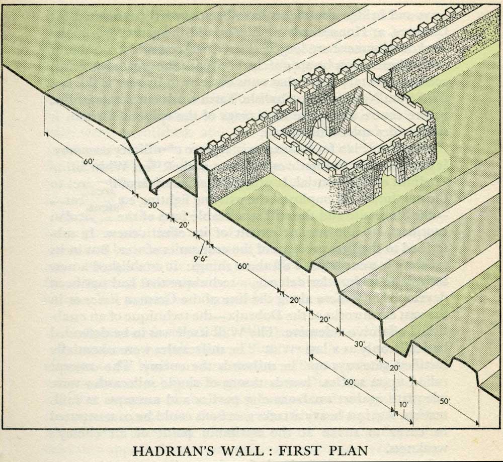
This first plan provided for a wall 10ft wide, 15ft 6 inches high and surmounted by a 6ft crenellation. to the north of this was a 20 ft berm, a standard fighting ditch 30ft by 13ft 6 inches, and a glacis composed of the spoil of the ditch, approximately 60ft in width. At each Roman mile was a milecastle with a north gate opening through the Wall, surmounted by a defensive turret and a south gate. In the original plan there were two barracks and the milecastle maintained a turret on either hand for the patrol garrison. South of the wall was the Vallum, a complex consisting of a 20 ft ditch with a wide bottom section and mounds composed of spoil to north and south. The wall was built to the design width only on the eastern slope. The Milecastles built before the change of plan had 10ft wings on either side. The curtain wall as finally built was substantially narrower and the join is indicated in the diagram. This information and the diagram taken from Richard Devine The Northwest Frontier of the Roman Empire Chap2 pg 27 |
|||||||||||||||||||||||||||||||||||||||||||||||||||||||||||||||||||||||||||||||||||||||||||||||||||||||||||||||||||||
 |
||||||||||||||||||||||||||||||||||||||||||||||||||||||||||||||||||||||||||||||||||||||||||||||||||||||||||||||||||||||
 |
||||||||||||||||||||||||||||||||||||||||||||||||||||||||||||||||||||||||||||||||||||||||||||||||||||||||||||||||||||||