|
|
|
|
 |
|
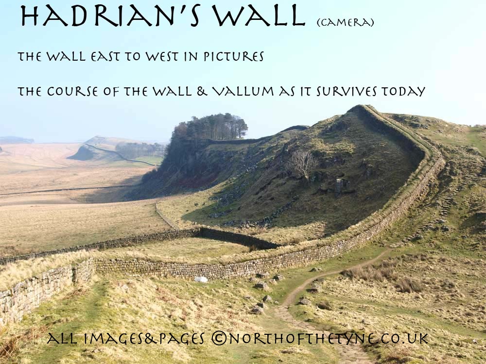
Page VIII
Brocolitia to Vercovicium
Milecastles 31 to 37
|
|
 |
 |
|
 |
|
|
|
|
|
 |
|
|
PROCOLITIA Fort to Vercovicium
Carrawburgh to Housesteads
The Wall leaves for the west from Carrawburgh undulating but straight towards Sewing shields Crags.
At this time the Wall line is under the Military Road but as the Wall heads for the Great Whin Sill two miles further west, the road will cut south through the Vallum to take the easier route.
The Wall ascends along the top of Sewingshields Grags to follow the ridge turning south west only to keep to the high ground before enclosing the vallwy of the Knag Burn on its approach to VERCOVICIUM.
Vercovicium / Borcovicium / Velurtion / BORCOVICUS as shown in the 1922 map above is known as Housesteads today
Roman Mile = 1620 yards = 0.92Mile = 1.48km

Start point for this page
|
|
|
|
|
|
|
|
|
|
 |
|
Location
|
Milecastle
|
|
Segedunum to Pons Aelis
|
|
|
Pons Aelis to Condercum
|
|
|
Condercum to Heddon
|
|
|
Heddon to Harlow Hill
|
|
|
Harlow Hill to Portgate
|
|
|
Portgate to Chesters
|
|
|
Chesters to Brocolitia
|
|
|
Brocolitia to Vercovicivm
|
|
|
Vercovicivm to MC40
|
|
|
MC40 to Aesica
|
|
|
Aesica to Carvoran
|
|
|
Carvoran to Birdoswald
|
|
|
Birdoswald to Hare Hill
|
|
|
Hare Hill to Newton
|
|
|
Newton to Stanwix
|
|
|
Stanwix to Dykesfield
|
|
|
Dykesfield to Maia
|
|
|
|
|
|
|
|
|
|
|
|
|
|
|
|
 |
|
|
|
|
|
PROCOLITIA FORT
The Fort at Carrawburgh added to the wall probably to fill the gap between CILURNUM and VIRCOVICIUM is an Infantry fort with no projection north of the line of the Wall. Added after the Vallum was established and built over it.
The site was known before Horsley who first ascertained that its side walls made right angled junctions with the main Wall, that it had no northerly projection and that its vicus lay mainly to its western side and that close to it there was a well. The well was lost for a century and a half being discovered again by Clayton who excavated it . below the rubble that choked the top he found at once thirteen thousand, four hundred and eighty seven coins. many more were carried away by in a raid by the locals but in Clayton's find were four coins of gold, one hundred and eighty-four of silver and bronze coins covering three hundred years of Roman history. *4
The Fort itself has seen little excavation but from the state of its surface that much of its buildings remains. there was a bathhouse excavated by Clayton in 1873 similar to that at Cilurnum but nothing remains today. Shown variously as Procolitia and Brocolitia.
In the second century the garrison was the first cohort of Aquitanians, later the first cohort of the Cugeranians and in the third and fourth centuries the first cohort of Batavians.*5
Wide shots - Top - From the east and the line of the wall . Bottom - From south east click for bigger views
|
|
|
|
|
|
|
 |
|
 |
|
|
 |
|
Temple of Mithras
This temple at Carrawburgh is the finest found in Britain.
*******************
Built by the soldiers based at Procolitia.
Mithras was an Eastern sun-god, supposedly born from heaven. According to legend, he had captured and killed in a cave a bull, the first creature created on earth, and from the blood that flowed all manner of creatures gained new life. This doctrine of new life through sacrifice is one that brought Mithraism into conflict with Christianity.
**********************
The temples were small, confined spaces, to represent the cave in which the bull-slaying episode took place. A large painting or sculpture of Mithras slaying the bull stood in front of three altars. It is clear that drama formed a part of the ceramonial; in one of the altars a series of pierced holes forms Mithras's crown, through which a lamp would have been shone at a high point of the ritual In addition, a curtain at the highest part of the temple would have been drawn back, allowing sunlight to stream in and illuminate the backdrop of Mithras slaying the bull, the triumph of light over darkness.
The statues, altars, and wooden posts in the temple site now, are all casts of finds made during excavations in 1949. The originals and a full-scale reconstruction of the Carrawbrugh Mithraeum can be seen at the Great Museum of the North / Hancock in Newcastle upon Tyne.
Roman buildings now seen as so drab were once brightly painted.
This notetaken from the information sign provided by English Heritage at the Temple
|
|
|
 |
|
|
|
|
|
The Wall sets off from Brocolitia heading for Sewing Shields Crags the Fighting Ditch to bee seen quite clearly the Vallum for the first mile faint to the south.
|
|
 |
|
 |
|
 |
|
 |
 |
|
 |
|
 |
|
|
 |
|
|
 |
|
|
|
|
 |
|
The site of Milecastle 32
In a field over the roadside wall
<<<< NY 846 710
|
 |
|
|
|
|
|
|
|
|
 |
|
 |
 |
|
|
 |
|
 |
|
|
|
|
To the south of the Wall line a field gate taking the contours of the Vallum >>>>>
|
|
|
|
|
|
 |
 |
|
 |
|
The road dives south with the Wall line to heading for Sewing Shields
To the south of the road at this point the Vallum is spectacular and runs very close to the line of the Wall. the "Military Way" holding the same course
|
|
|
 |
|
|
|
 |
|
 |
|
 |
|
 |
|
|
 |
 |
|
 |
 |
|
|
 |
|
|
The site of Milecastle No. 33
"Shield on the Wall"
|
|
|
|
|
|
|
|
|
|
 |
|
 |
 |
|
 |
|
 |
|
 |
Beyond Milecastle 33 there is a dry stone wall sitting on the rubble of the Roman Wall.
Over a stile to the left can be seen the deep Vallum and Military Way while ahead there are noteable remains of Turret 33b
|
|
|
|
|
|
|
|
 |
 |
|
Climbing now towards the Great Whin Sill the Wall line can be easily identified up to and beyond Grindon Milecastle No.34
|
|
|
|
|
|
|
|
|
 |
 |
 |
|
 |
|
 |
|
|
|
|
|
|
above
The site of Milecastle No.34
Grindon
|
|
|
|
|
|
|
<<<<<<<< About a hundred yards west of Milecastle 34 the Fighting Ditch was deemed no longer required and abruptly comes to a stop.
|
|
|
|
|
|
|
|
|
 |
|
 |
 |
Through a stile on the approach to Sewing Shields Farm are the remains of Turret 34a
|
|
|
|
|
|
|
 |
 |
 |
|
|
The Wall made some sort of sharp deviation here and has been obliterated to re-appear entering the wood which surrounds Sewing Shields Farm
|
|
|
|
|
|
 |
 |
|
 |
|
|
|
 |
 |
|
|
 |
|
 |
|
 |
 |
|
|
|
 |
|
|
 |
|
|
|
|
|
|
The Wall line runs through the back of the Sewing Shields Farm, built entirely from the stones of the Wall, and can be seen as a ridge running up though the woodland out onto the open Fell.
Long stretches of Wall a few feet high can now be found following the ridge line of Sewing Shields Crags all the way up to trig point 325 at OS _ NY 801 701
|
|
|
|
|
|
|
 |
 |
|
 |
|
 |
|
|
 |
 |
|
The narrow chasm down to the north just past Sewing Shields is called Cat's Gate using this the Scots according to tradition crawled under the Wall.
The oblong chamber abutted hard to the Wall on this has been the subject of some study and is thought to be a burial Cist probably of a soldier who has died during the construction ! more info to follow.
|
|
|
|
|
|
 |
|
The site of Milecastle No.35
NY 805 702
<<<<<<<<<<
|
|
|
|
 |
|
 |
|
 |
|
 |
|
|
 |
|
 |
|
 |
|
 |
|
|
|
|
|
 |
|
Above
A look back along Sewing Shields Crags
|
|
|
|
|
|
|
|
 |
 |
|
|
Just before the trig point is the site of Turret 35a
|
|
|
|
|
|
 |
 |
|
 |
 |
|
The expanse of water seen from the hilltop is Broomlee Lough
|
|
 |
|
<<<<<<<<<<<<<<
At the summit the Wall turns south down to "Busy Gap"to rise westward again on to the crests of the Whin Sill
|
|
 |
|
|
|
|
"Busy Gap"
In 1599 when Camden and Cotton Antiquaries visited they dared nor go to Busy Gap it being the haunt of thieves and robbers.
The dry stone wall sits on the base of the Roman Wall
<<<<<<<<<<<<<<<
The stile is a point called King's Wicket
|
|
|
|
|
|
|
 |
|
|
|
|
|
|
|
|
|
 |
|
 |
|
<<<<<<<<<< The site of Milecastle No.36
King's Hill
NY 797 693
No evidence remains on the ground but it stood on a slope of one in five
|
|
|
|
|
|
|
|
|
|
|
 |
|
 |
|
 |
 |
 |
|
 |
|
From milecastle 36 the Wall runs down the ledge of Kennel Crags and into a small wood to exit with a magnificent stretch of wall running down and accross the Knag Burn and beyond up to join with the NE corner of VERCOVICIUM
|
|
 |
|
|
|
|
The KNAG BURN Gateway
This gateway along with the one at Portgate were rare and were used for civilian purposes.
This fourth century gateway was discovered by John Clayton in 1856 and has been carefully reconstructed. the culvert by which the burn underran the wall has been rebuilt following Clayton's slightly suspect repair. The Wall itself here , largely repiled by Clayton's men, has been reconsolidated up the slope to the Housesteads rampart. *1
*******************
The Fort of VERCOVICIUM is reached at the botched up junction of the north-east corner. one of the rewarding things about his site is that the laymen can see here for himself the anomalities of its origins, can trace the indecisions, the alteration of Plans *1
|
 |
|
|
|
 |
 |
|
|
 |
|
 |
 |
|
VERCOVICIUM
The name given to the eighth Fort on the Wall in the Notitia. The area covered by the fort is 5.75 acres.
The fort is known as Housesteads today
The first Roman buiding here was probably Turret 36b now consolidated into the Fort the North rampart of the Fort being Hadrian's Wall
The information about Vecovicium will be found on the next page IX
|
 |
|
 |
|
|
 |
|
 |
|
 |
A painting of John Clayton depicted as a Centurion. The original is to be seen at Wallington Hall a National trust property in Northumberland.
|
|
|
Milecastle 37 lies just west of Housesteads. The line from Housesteads to the fort and on to Milecastle 40 will be covered on page IX
|
|
|
|
|
|
|
References page 8
*1 David Divine - The North East Frontier of Rome 1969 Pg 117
|
|
 |
|
|
|
|
|
|
|
|
|
|
|
|
|
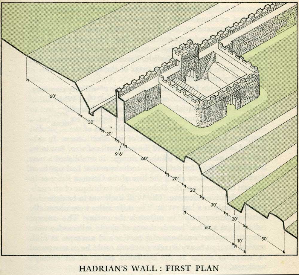 |
Milecastles
This first plan provided for a wall 10ft wide, 15ft 6 inches high and surmounted by a 6ft crenellation. to the north of this was a 20 ft berm, a standard fighting ditch 30ft by 13ft 6 inches, and a glacis composed of the spoil of the ditch, approximately 60ft in width.
At each Roman mile was a milecastle with a north gate opening through the Wall, surmounted by a defensive turret and a south gate. In the original plan there were two barracks and the milecastle maintained a turret on either hand for the patrol garrison.
South of the wall was the Vallum, a complex consisting of a 20 ft ditch with a wide bottom section and mounds composed of spoil to north and south. The wall was built to the design width only on the eastern slope. The Milecastles built before the change of plan had 10ft wings on either side. The curtain wall as finally built was substantially narrower and the join is indicated in the diagram.
This information and the diagram taken from Richard Devine The Northwest Frontier of the Roman Empire Chap2 pg 27
|
|
|
|
|
|
|
|
|
|
|
|
|
|
|
|
|
|
|
|
|
|
|
|
|
|
|
|
|
|
|
|
|
|
|
|
|
|
|
|
|
|
|
|
|
|
|
|
|
|
|
|
|
|
|
|
|
|
|
|
|
|
|
|
|
|
|
|
|
|
|
|
|
|


